Geodesy and geophysics
Geophysics is the study of the substances that make up the Earth and the physical processes occurring on, in and above it.
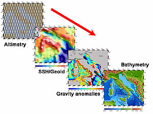
Electromagnetic waves emitted and received by the satellite do not penetrate far beneath the sea surface. Altimetry satellites do measure range from the satellite to the surface, but the estimated sea surface height also comprises the cumulative impact of many phenomena over the whole water column. Thus we can deduce from these measurements what's happening in the depths.
Altimetry became an essential contribution to be used to study the Earth's shape and size, gravity anomalies (geodesy), seafloor relief (bathymetry), tectonic plate motion and rifts (geophysics), etc. Although often linked to plate tectonics, tsunamis are very different, transient phenomena. However, their impact on the sea surface can be seen by altimeters in some cases, thus helping the study of their propagation.
On this theme, you can consult :
Further information:
- McAdoo, D., Marine Geoid, Gravity, and Bathymetry: An increasingly clear view with satellite altimetry, 15 years of progress in radar altimetry Symposium, Venice, Italy, 2006.
- List of Geodesy and Geophysics links

