Past missions
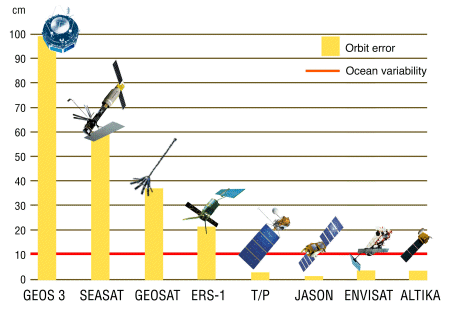
Altimetry was announced as a priority at the Williamstown Symposium in 1969. The 1970s saw the development of accurate satellite altimeter systems, with Skylab (which produced the first measurements of undulations in the marine geoid due to seafloor features), Geos-3 and Seasat, whose data were widely and freely distributed to scientists throughout the world, laying the foundations for a new generation of ocean satellites. In the 1980s, only Geosat was launched, whose data was at first classified.
In the 1990s, Topex/Poseidon, with precise orbitography and location system like Doris, the accuracy of the satellite positionning began to enable monitoring of sea surface height variations due to low-amplitude ocean dynamical processes. With also ERS-1 (and ERS-2 afterwards), alltimetry began providing vital information to a growing international user community.