News
21.06.2017 14:41 Age: 7 yrs
Special Issue of Remote Sensing, "Satellite Altimetry for Earth Sciences" in preparation
Category: Events
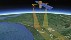 Satellite altimetry was initially designed for measuring the ocean’s topography, with reference to an ellipsoid, and for the determination of the marine geoid. Satellite altimetry has provided extremely valuable information on ocean science (e.g., circulation surface geostrophic currents, eddy structures, wave heights, and the propagation of oceanic Kelvin and Rossby waves). With more than 25 years of observations, it is also becoming vital to climate research, providing accurate measurements of sea level variations from regional to global scales. Altimetry has also demonstrated a strong potential for geophysical, cryospheric and hydrological research, and is now commonly used for the monitoring of Arctic and Antarctic ice shet topography, and of terrestrial surface water levels.
A Special Issue of Remote Sensing, "Satellite Altimetry for Earth Sciences" is in preparation. It aims to present reviews and recent advances of general interest in the use of radar altimetry in Earth sciences. Manuscripts can be related to any aspect of radar altimetry technique or geophysical applications. Manuscript resulting from application of new altimetric technology (SAR, SARin and Ka band) and improvements expected from missions to launched in the close future (i.e., SWOT) are also encouraged.
Contributions can be either a review paper on some specific topics, or an original research in this area. For more information about the Special Issue, please see:
This Special Issue aims to present reviews and recent advances of general interest in the use of radar altimetry in Earth sciences. Manuscripts can be related to any aspect of radar altimetry technique or geophysical applications.
A Special Issue of Remote Sensing, "Satellite Altimetry for Earth Sciences" is in preparation. It aims to present reviews and recent advances of general interest in the use of radar altimetry in Earth sciences. Manuscripts can be related to any aspect of radar altimetry technique or geophysical applications. Manuscript resulting from application of new altimetric technology (SAR, SARin and Ka band) and improvements expected from missions to launched in the close future (i.e., SWOT) are also encouraged.
Contributions can be either a review paper on some specific topics, or an original research in this area. For more information about the Special Issue, please see:
- <link http: www.mdpi.com journal remotesensing special_issues sa _blank external-link-new-window>www.mdpi.com/journal/remotesensing/special_issues/SA

