News
05.10.2018 11:46 Age: 6 yrs
Copernicus Sentinel-3 improves observation of inland waters
Category: Website updates
 While world-class scientists are meeting in the Azores to discuss how satellites have revealed changes in the height of the sea, ice, inland bodies of water and more, the Copernicus Sentinel-3 satellite has new reasons to shine.
Radar altimeters record the surface topography along the satellite's ground track. They precisely measure the height of water, land and ice by timing the interval between the transmission and reception of very short radar pulses.
This is the only technology that can measure, systematically and globally, changes in the height of the ocean - and is therefore essential for monitoring sea-level rise.
After a successful commissioning phase (flying 30 seconds apart in tandem with its twin Sentinel-3A), the Sentinel-3B satellite of the European Union's <link http: www.copernicus.eu blank>Copernicus Programme will be moved, in October, to its final orbit.
During this drift period, the altimeter will be uploaded with new Open-Loop Tracking Command (OLTC) tables, which are used to control the return echo acquisition phase of the altimeter by setting its reception window. This on-board process ensures recording reliable and quality measurements over inland waters.
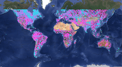
These tables have been upgraded with more than 32,500 virtual stations defining lakes, reservoirs, rivers and even glaciers worldwide, as shown on the featured image.
More information <link https: sentinel.esa.int web sentinel news asset_publisher xr9e content external-link-new-window>here.
While world-class scientists are meeting in the Azores to discuss how satellites have revealed changes in the height of the sea, ice, inland bodies of water and more, the Copernicus Sentinel-3 satellite has new reasons to shine.
Radar altimeters record the surface topography along the satellite's ground track. They precisely measure the height of water, land and ice by timing the interval between the transmission and reception of very short radar pulses.
This is the only technology that can measure, systematically and globally, changes in the height of the ocean - and is therefore essential for monitoring sea-level rise.
After a successful commissioning phase (flying 30 seconds apart in tandem with its twin Sentinel-3A), the Sentinel-3B satellite of the European Union's <link http: www.copernicus.eu blank>Copernicus Programme will be moved, in October, to its final orbit.
During this drift period, the altimeter will be uploaded with new Open-Loop Tracking Command (OLTC) tables, which are used to control the return echo acquisition phase of the altimeter by setting its reception window. This on-board process ensures recording reliable and quality measurements over inland waters.
These tables have been upgraded with more than 32,500 virtual stations defining lakes, reservoirs, rivers and even glaciers worldwide, as shown on the featured image.
More information <link https: sentinel.esa.int web sentinel news asset_publisher xr9e content external-link-new-window>here.
While world-class scientists are meeting in the Azores to discuss how satellites have revealed changes in the height of the sea, ice, inland bodies of water and more, the Copernicus Sentinel-3 satellite has new reasons to shine.

