Swot Data Products
Data Products for Hydrology
Four main products have been defined. The pixel-cloud and raster products are in NetCDF format, while the river and the lake are in shapefile format, compatible with GIS. River- and lake-specific products are linked to a priori databases, which will be updated all along the mission.
"River" products
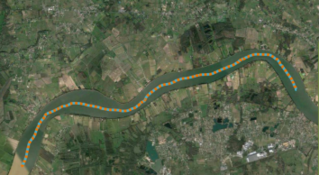
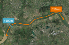
Each river over 30 m wide is defined in an a priori database, as a line along the centre of the river divided into reaches of 10 km long, and as nodes every 200 m along this line.
River products are provided according to these two types of breakdown, as defined in the a priori database: for the "node" file, with mean values around each node for parameters such as width, height, flooded area, etc., and for the "reach" file the mean height, mean slope, mean flow, etc. on each of these river reach.
These products are provided for each satellite pass.
The "reach" file product is also provided by cycle, in which case the values of the variables are provided on each of the different passes that measured all or part of the section of the river in question during an entire satellite cycle (21 days).
"Lake" products
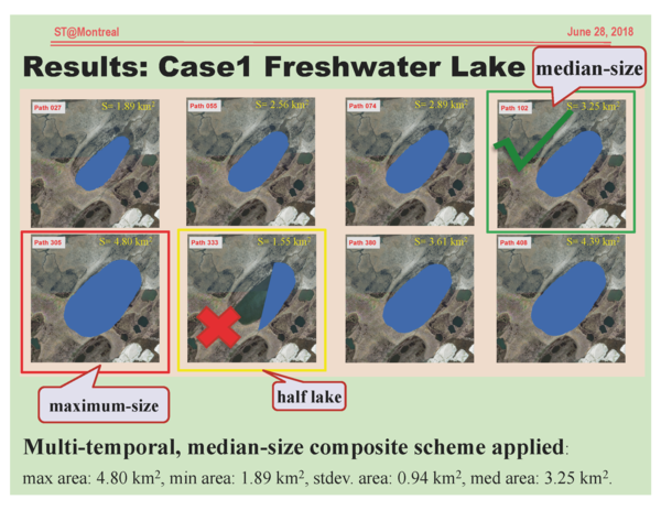
Water surfaces that are not known rivers, and that are more than one hectare in size, are treated as "lakes".
The product for each individual satellite pass gives information (height, surface area, contour, etc.) for each observation of these surfaces.
For each object that can be linked to an element of the a priori lakes database, the identification information is added.
The product for each cycle includes a median contour, and the average height of the lakes for passes when they were seen in their entirety (observations of only part of the lake are not taken into account). Other more complex scenarios (views of different parts of the lake at each passage) are taken into account.
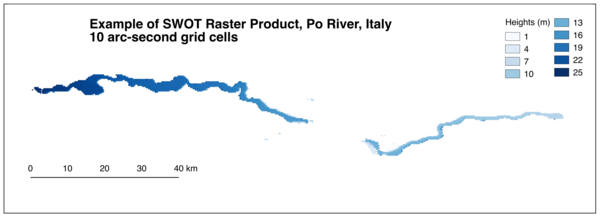
"Raster" products
A "raster" product (see the example of the Po above) is systematically generated from the "pixel cloud" product. It is in NetCDF 2D format, covering four point-cloud tiles (the 2 swaths and 120km along the ground track) and coming in two resolutions: 100 m and 250 m. The raster product is given on a regular grid according to a Universal Transverse Mercator (UTM) projection. This is a one-per-pass product.
It can also be generated on demand (via the data dissemination portal):
- format: NetCDF, GeoTiff, etc.,
- subset of variables,
- resolution (>100m) and user-defined area, with a limit on the volume of the data to be downloaded.
"Pixel cloud" product
This is the rawest product for land surfaces. A file, in NetCDF format, covers a tile, which corresponds to a swath on one of the two sides (left or right) over 60 km along the satellite's ground track.
The product provides longitude, latitude, height, pixel size, corrections and uncertainties for each point classified as water, for points on a buffer zone around these water zones as well as on systematically included areas (defined according to an a priori mask).
This product is generated for each pass of the satellite.
There is also a companion product called the pixel-cloud vector product which includes height-constrained geolocation and assignement to river and lake database.
(Left: raw pixel cloud product – Right: pixel-cloud vector product)
Data Products for Oceanography
Oceanographic data over the open ocean are "low resolution", pre-processed on board.
The variables provided in the data and formats are quite similar to the Geophysical Data Records existing in conventional altimetry, but on swaths (so in two dimensions instead of along the track).
Several variants of these products are distributed, in half orbits (tracks), at 2 x 2 km resolution, every 2 km, on a grid following the ground track:
- SSH/SSHA "basic" products
- wind / waves / sigma0 "Basic" product
- Expert products, with the information of the SSH/SSHA commodities, but also all the corrections, auxiliary data, etc. necessary for their calculation (note some additional corrections compared to conventional altimetry, in particular errors induced by the roll angle, and internal tides)
These three data sets being provided
- on the actual ground track (which may vary by +/- 1 km from the theoretical orbit)
- and also in variants projected on the theoretical ground track (therefore always stable from one cycle to the next).
- A final expert dataset "SSH and Sigma0 Power and Variance", with a native resolution of one pixel of 500 m x 500 m every 250 m, is also available.

Access the data
See the simulated data products (over ocean) in Aviso data catalogue, or the Ocean data challenges product used to perform studies about the future constellations such as the use of the Swot mission.

