Jellyfish on the move
Image of the Month - May 2012
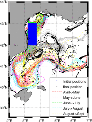
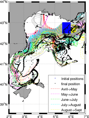
Two different modelings of 40 day trajectories of virtual jellyfishes, computed with altimetric surface currents (launched each month from 2 different locations -- blue dotted areas). The black dots note the final location of those virtual jellyfishes (Credits MIO, Jellywatch project)
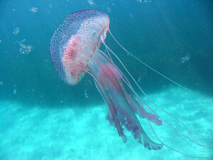
Jellyfish are passively carried by ocean currents. Jellyfish blooms are frequently observed at different coastal zones worldwide. The Mediterranean coasts of France and Spain are among the areas which are regularly impacted by large concentrations of jellyfish, in particular by the stinging jellyfish Pelagia noctiluca. In this context, the Jellywatch project aims at forecasting strandings of Pelagia noctiluca in the North-western Mediterranean Sea.
Altimetry enables to describe ocean currents. However, altimetry data are classically processed over open ocean, while the interest on jellyfish transport is in the coastal areas. So, specific processing must be applied to compute "coastal" altimetry data to use in such applications. Moreover, it is important to take into consideration the daily vertical migration of Pelagia noctiluca jellyfish which spends the day at depth and surfaces at night. Therefore a 3-d regional model has to be used, in synergy with altimetry and tools enabling to follow the path of a mobile (lagrangian tools) to fully understand their drift.
See also:
- Image of the Month, July 2001: Altimetry and lobsters
- Image of the Month, October 2011: Crustaceans off Chile
- Image of the Month, January 2008: Like a stone carried away by the current
- Applications: Biology
Other websites on this subject:
- Jellywatch project (in French)
References
- Ferraris M., L. Berline, F. Lombard, L. Guidi, A. Elineau, M. Mendoza-Vera, M.K.S. Lilley, V. Taillandier, G. Gorsky, 2012: Distribution of Pelagia noctiluca (Cnidaria, Scyphozoa) in the Ligurian Sea (NW Mediterranean
Sea), Journal of Plankton Research, 34(10), 874-885 - Bouffard, J, A M. Doglioli, R. Escudier, A. Petrenko, A Pascual, F Nencioli, Z. F. Qiu and F. Carlotti (2011): On the influence of coastal mesoscale dynamics on the jellyfish trajectories and distributions, 5th Coastal Altimetry Workshop, October 2011, San-Diego, USA. (Talk, paper in preparation)
- Bouffard, J, A M. Doglioli, R. Escudier, A. Petrenko, A Pascual, F Nencioli, Z. F. Qiu and F. Carlotti (2011): Lagrangian analysis of 3D mesoscale dynamics from altimetry and modelling: application to Jellyfish tracking over the North western Mediterranean Sea. OSTST meeting, October 2011, San-Diego, USA. (Poster)

