Ice on the Ob River retrieved by Jason
Image of the Month - January 2022

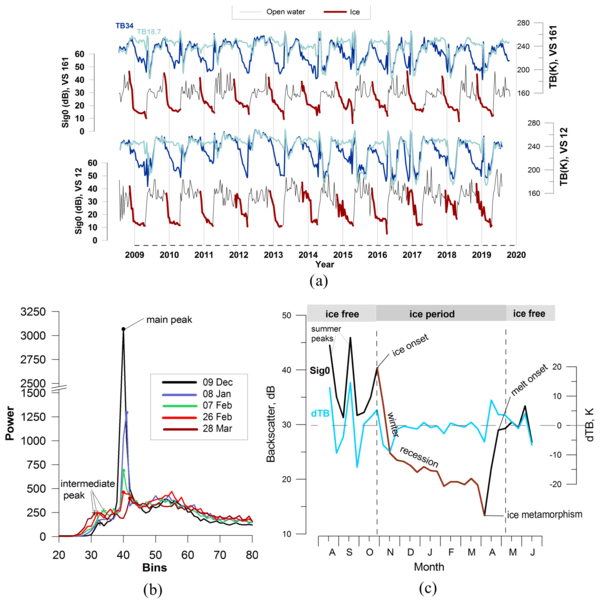
More than half of the northern hemisphere river lengths (58 %) are iced at some point of their seasonal cycle. This impacts the ecosystems, the environment as well as society (hydropower, navigation, fishing etc.). It is thus of foremost importance to know the ice conditions, while measuring them in situ can be complicated (and potentially risky). Satellites can help, even if optical or infrared sensors are limited by cloud cover and night length up North. Radar altimeters have no such limitation, and provide with measurements. Here we are not so much interested in the heights provided by the radar altimeter than in the backscatter coefficient(the power of the return vs emitted radar signals), and in its dynamics along the year.
Some studies hinted that depending on the frequency used, the reflexion of the radar signal can be at the snow-ice interface or at the water-ice one, which could be used to estimate the ice thickness. However, those were done over large northern lakes, while rivers are much smaller. But some seasonal events are identifiable and matched with backscatter coefficients changes. A steep rise is correlated with freezing-up, likely in link with the fact that the skim ice is at first very smooth, so reflects back the radar signal well to the altimeter. The altimetric signal, in Ku-band at least, is also affected by scattering within the ice layer, which lower the power of the return signal straight to the altimeter. Thus, the thicker the ice, the lower the backscatter.
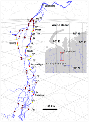
Such considerations enabled an international team to establish empirical algorithm to try and estimate freeze-up date, ice growth and thickness and ice breakup dates over the Ob River (Siberia, Russia) using Jason-2 and 3. Results are promising and provided 7-18% of accuracy for ice thickness retrievals.
Using the method with several satellites - altimetry ones, but potentially optical or SAR ones, too -- could help to expand the results to other Arctic rivers, and complete the method and coverage.
See also:
- Data: (I)GDRs
- Image of the Month, July 2013: Ob bogs and wetlands
- Image of the Month, May 2006: Ice on lake Baikal
- Applications: Ice
Reference:
- Zakharova, E., S. Agafonova, C. Duguay, N. Frolova, A. Kouraev, 2021: River ice phenology and thickness from satellite altimetry: potential for ice bridge road operation and climate studies, The Cryosphere, 15, 5387–5407, 2021, https://doi.org/10.5194/tc-15-5387-2021


