Jason-2 on the tracks of Jason-1 (and Topex/Poseidon)
Image of the Month - July 2008
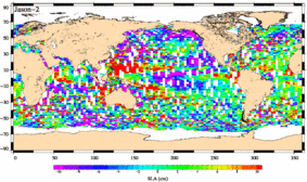
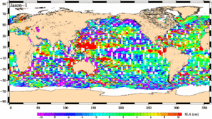
Jason-2 Sea Level Anomaly map (left) plotted from 2008-06-25 to 2008-06-30 data; right the same map plotted from Jason-1 equivalent data (Credits Cnes/CLS)
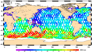
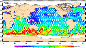
Jason-2 Significant Wave Height map (left) plotted from 2008-06-25 to 2008-06-30 data; right the same map plotted from Jason-1 equivalent data (Credits Cnes/CLS)
Jason-2 was launched on June 20, 2008. Now, on July 4, it is moved on its final orbit, 55 seconds behind Jason-1 for the calibration phase. Both satellites measuring the same things, or very near, comparisons will made it possible to fine-tune Jason-2 on Jason-1, so that the continuity between both satellites is ensured, and further than that, the continuity of Topex/Poseidon measurements. This will provide at least twenty years of homogeneous (in four years), intercalibrated data, an especially important quality for some altimetry applications, like the Mean sea level monitoring.
Even if Jason-2 was not yet on its final orbit, and if there have been manoeuvres (and the Poseidon-3 altimeter was even switched off and on during one of them), Calibration/Validation processes begun, with promising results. The statistics made over the measurements are very close to Jason-1's. The maps that are beginning to be built are also close for the two satellites. cycle 0 begins today, July 4th; cycle 1 (the first full 10 day cycle) will begin on July 12. Calibration and validation of the data will continue, up to the end of the Calval phase, and after Validation will be done in routine mode, as it is the case for Jason-1.
See also:
- Missions: Jason-2/OSTM
- Calval
Websites on this subject:
- Jason-2 blog (Cnes, in French)
- Jason-2 (Space scientific missions - Cnes)
- Jason-2 (Eumetsat)
- Jason-2/OSTM (Noaa)
- OSTM (Nasa)
- OSTM/Jason-2 (Ocean Topography from Space, Nasa/JPL)

