Sahelian dry and wet seasons seen by altimetry
Image of the Month - December 2014
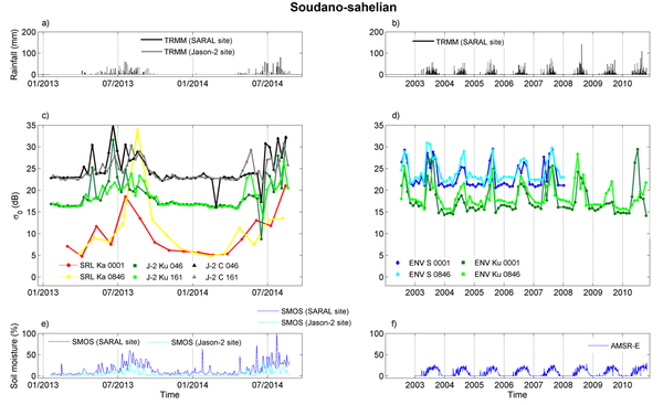
Initially designed to monitor the dynamic topography of the ocean, nadir-pointing radar altimeters have proven their capacities for the study of continental surfaces and for land hydrology, allowing long-term observations of water level variations for land hydrology. The magnitude of radar altimeter backscattering coefficients is also related to the dynamics of surface properties. Spatial and temporal variations of radar altimeter backscattering coefficients were found to be related to soil roughness and surface soil moisture changes in semi-arid areas, such as Sahel.
In Sahel, soil moisture drives many surface processes including soil organic matter mineralization, vegetation productivity, land surface fluxes and land surface–atmosphere interactions. Radar altimetry offers a new opportunity for the monitoring of this key variable in regions where in-situ observations are scarce.
See also:
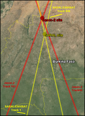
- Data: Saral (I)GDRs
- Image of the Month, December 2011: Missing: Water
- Image of the Month, July 2013: Ob bogs and wetlands
- Image of the Month, January 2004: Altimetry over land
- Applications: Hydrology and land
Reference:
- C. Fatras, F. Frappart, E. Mougin, M. Grippa, P. Hiernaux, 2012: Estimating surface soil moisture over Sahel using Envisat radar altimetry, Remote Sensing of Environment, 123 (2012), 496-507.
- Result shown hereF. Frappart, E. Mougin, P. Borderie, C. Fatras, personal communication

