Through Indonesia
Image of the Month - April 2015
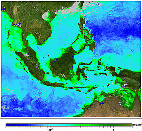
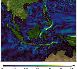
Chlorophyll-A (from Virrs) and model current speed (assimilating altimetry data) for March 25, 2015. The threads of current going out of the area by the South (Lombok Strait) is clearly visible in both data (click to enlarge each map). This is one of the outputs of the Indonesian ThroughFlow.
The Indonesian Archipelago is a key area to understand the circulation at global scale, since it plays a major role in the thermohaline circulation.The Indonesian ThroughFlow, i.e. the current which goes through the archipelago drains water from the tropical Pacific into the Indian Ocean, with tidal mixing blending these incoming Pacific waters into different water masses.. It is a region where the bottom bathymetry is complicated, where numerous narrow straits and small interior basins exist. Indonesia is also a country living in a large part on marine resources, with mostly coastal population, thus rendering extreme events from the ocean a major threat.
Ocean satellite monitoring and studies is thus a vital activity in the area, and benefits from the data taken (among others) by altimetry satellites. Continuity, and the resolution improvement which will be brought by SWOT will improve things even further.
See also:
- Applications: Multi-sensors
- Applications: Ocean circulation and its variations
- Data: Ssalto/Duacs near-real and delayed time multimission altimeter products

