Swot and the lakes' winds
Image of the Month - June 2021
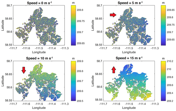
Canada is one of the countries with the highest number of lakes on Earth. They represent a significant part of the surface freshwater of the country. In a number of cases several lakes are very close, interconnected and can even merge with their neighbouring lakes during some extreme events. This tends to complexify the observations, either in situ or by satellite. Moreover, winds can influence the water height repartition over a whole lake and its connected neighbours. The wind pushes the surface waters towards the opposite shore (a phenomenon known as "seiche"), thus increasing the level on that shore, decreasing it on the other. Differences between shores can reach up to 3 m (Lake Erie, eastern Canada). Water fluctuations during wind seiches on Lake Athabasca (western Canada) have been observed to lead to differences in water height of up to 1 m. They can also push water into adjacent, connected, lakes. Swot will measure the height and extent of such lakes, improving our knowledge of complex areas like these. Canada is part of the mission with a contribution to the satellite from the Canadian Space Agency, and several teams involved in its preparation.
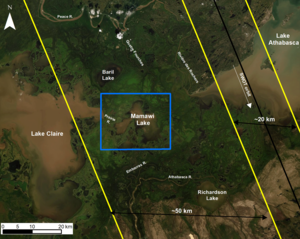
Lake Mamawi is one of the large, relatively shallow, interconnected lakes found in the Peace–Athabasca delta (a Ramsar
wetland site). Its extent is difficult to estimate due to the heavy vegetation and soft soil (mud) surrounding it and the seasonal variability in the water level. This particular lake will be overflown completely by one of the Swot swath. However, what would be the retrieved water heights for an partial coverage of such a lake, when winds are blowing? A study from Sherbrooke University tries to answer this question, and concludes that winds, including their direction, will be an important information for water height estimation when the Swot swath coverage of a lake will only be partial.
The Swot Science Team is actively preparing the future use of the mission's data -- launch is still planned in one year and a half.
See also:
- Applications / hydrology: lakes and enclosed seas
- Applications: High-resolution hydrology
- Missions: Swot
Reference:
- Jean Bergeron, Gabriela Siles, Robert Leconte, Mélanie Trudel, Damien Desroches, and Daniel L. Peters, 2021: Assessing the capabilities of the SurfaceWater and Ocean Topography (SWOT) mission for large lake water surface elevation monitoring under different wind conditions, Hydrol. Earth Syst. Sci., 24, 5985–6000, 2020, https://doi.org/10.5194/hess-24-5985-2020

