Snow on sea ice
Image of the Month - October 2021
![Time serie of annual mean snow depths for most of the different available snow depth products in the Arctic (a). The time serie (b) represent sea ice thicknesses computed from identical CryoSat-2 altimetric freeboard but with varying snow depths. It highlights the important impact of the snow depth on sea ice thickness estimations. During the period of 2013-2019, [Garnier et al, 2021] found a spatially averaged Sea Ice Thickness mean standard deviation of about 20 cm. (Credit Legos)](/fileadmin/_processed_/e/4/csm_202110_tc-2021-79-2_3c99f3d51f.png)
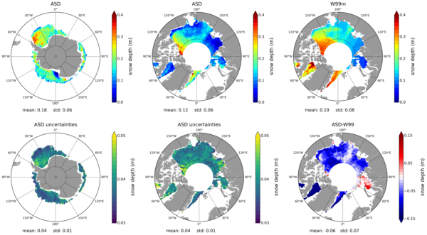
Snow also falls on sea ice. This is not anecdotic, since it might leads to an overestimation of sea ice thickness of about 450 times the equivalent water quantity of six months of Amazon discharge, on one side. And on the other side, snow can act as an insulator over this sea ice, slowing down its melt in summer and growth in winter. Knowing its depth is thus of foremost importance. Up to recently, this was mostly done using a climatology computed from in situ data (Warren-99), dating mostly from before the most significant impacts of global climate change on polar regions.
The different radar frequencies used by altimetry satellites do not interact similarly on snow or on ice. The Ka-band signal (AltiKa altimeter onboard Saral) is assumed to be reflected near the top of the snow pack (at the air/snow interface). The Ku-Band (onboard most altimetry satellites) is assumed to penetrate at least partially the snow. It can thus reach the snow/ice interface, depending on the type of snow. Comparing measurements from the two different frequencies can thus provide with an estimate of the snow depth over the ice.
No satellite to this day had carried a dual-frequency altimeter with two particular bands, but Saral has flown at the same time than Cryosat-2 since 2013 and thus the two satellites can be used for the comparison. For previous years, the monthly climatology computed from this period [Garnier et al., 2021] can be used to estimate the snow depth, and thus recover the ice volume, over both Southern Ocean around Antarctica and Artic Ocean.
Studies using those two bands, begun by Legos and Cnes in 2016 [Guerreiro et al., 2016], led to the design of new dual-frequency, polar-dedicated, altimeters. Thus, the EU Copernicus Cristal project would be the first to carry an altimeter emitting in both Ka and Ku band. If confirmed, it will simultaneously measure snow and ice thicknesses. And thus significantly improve estimates of volume variations linked to global climate change. If not decided quickly enough to take over Cryosat-2 and Saral, there is a real risk of a gap in Arctic sea ice monitoring (see Polar scientists wary of impending satellite gap)
See also:
- Data: altimetry sea ice datasets from CTOH
- Missions: Saral, Cryosat-2
- Applications: Sea ice
Reference:
- Garnier, F., Fleury, S., Garric, G., Bouffard, J., Tsamados, M., Laforge, A., Bocquet, M., Fredensborg Hansen, R. M., and Rémy, F.: Advances in altimetric snow depth estimates using bi-frequency SARAL/CryoSat-2 Ka/Ku measurements, The Cryosphere Discuss. [preprint],https://doi.org/10.5194/tc-2021-79, in review, 2021.
- Guerreiro, K., S. Fleury, E. Zakharova, F. Rémy, A. Kouraev, 2016: Potential for estimation of snow depth on Arctic sea ice from CryoSat-2 and SARAL/AltiKa missions. Remote Sensing of Environment, Volume 186, 1 December 2016, Pages 339-349, https://doi.org/10.1016/j.rse.2016.07.013

