Altimetry helps search for a wreck
Image of the Month - August 2010
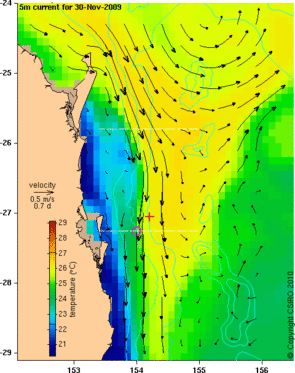
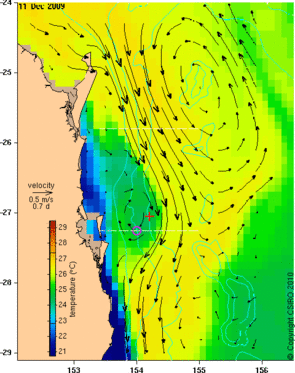
Near-surface (at 5 m depth) temperature and current velocity map from the Bluelink model for 30 Nov 2009 (left) and for 11 Dec 2009 (right). The locations of the AHS Centaur (magenta circle) and where survivors were rescued (red cross) are also shown. It is supposed that the flow on 14 May 1943 was more similar to the situation on 11 Dec 2009 than the more usual condition of 30 Nov. Had the flow been as strong as usual, more lives would probably have been lost.
See also the animation (1.2 MB) (Credits CSIRO)
The Australian Hospital Ship (AHS) Centaur was sunk during World War II off the coast of Brisbane (Queensland, Australia). However, the place of the wreck was not surely known, especially since the estimate given by survivors seemed in contradiction with the place they were found with respect to the main current in that area (the East Australian current, flowing southward). However, looking at the model data (from the BlueLink Australian operational altimetry project), it was shown that the current could indeed reverse in that area. The fact that two altimetric tracks (Jason-1 and Jason-2) provided measurements in the immediate vicinity, measurements that were assimilated in the model, gave all the more confidence in this possibility. Thus the search was conducted where the survivors indicated the ship was wrecked, and was successful.
Altimetry and operational oceanography models can be used to solve past events. But they can also help nowadays rescues at sea, saving lives.
See also:
- Data: Ssalto/Duacs near-real and delayed time multimission altimeter products
- Image of the Month, January 2008: Like a stone carried away by the current
- Image of the Month, August 2005: Satellites shed light on the Kon Tiki story
- Applications: Ocean large-scale circulation

