Surface mirrors the deep
Image of the Month - January 2010
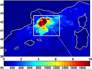
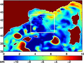
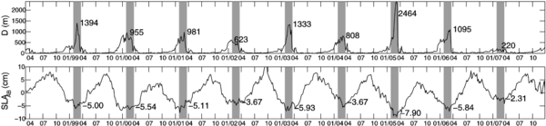
Depth of the ocean layer where waters mix (or mixed layer depth; the area where deep convection occurs can be identified as the region where the mixed layer is significantly deep) and sea level anomaly map. The sea level anomaly map lows match the area where the mixing occurs in depth, even if this is not unequivocal (the sea level anomalies can be low for other reasons). The white line is the T/P-Jason-1 track 146, in black the segment considered as an indicator (Credits Météo France/Legos).
The Northwestern Mediterranean Sea is one of the few regions on Earth where the ocean waters sink to the bottom. This ocean deep convection is a key process of the global thermohaline oceanic circulation, at the origin of deep water formation in the world's oceans and under the influence of climate change. Part of the Western Mediterranean deep water formed by deep convection in the Northwestern Mediterranean Sea flows in the Atlantic Ocean through the Gibraltar Strait, and may affect the global thermohaline circulation through the impact of the Mediterranean Outflow Water on North Atlantic deep convection.
However, monitoring it in situ is rather costly and time-consuming. Altimetry cannot measure directly such phenomena -- no space techniques can. However, through the effects of its variations on the sea surface height, the deep convection variations can be monitored from space.
See also:
- Image of the Month, June 2001: An in-depth view
Website on this subject:
- Altimetry data used from CTOH, ("MAP" data, sampled every 2 km with coastal-dedicated processing)
References:
Herrmann, M., J. Bouffard, and K. Béranger, 2009: Monitoring open-ocean deep convection from space, Geophys. Res. Lett., 36, L03606, doi:10.1029/2008GL036422

