Arctic sea ice shrinks and thins
Image of the Month - February 2010
Arctic is one of the most sensitive regions to climate change. The sea ice is especially sensitive, and its vanishing could have serious impacts.
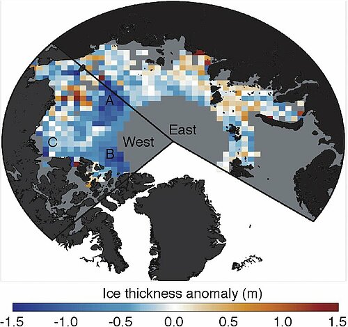
September 2007 saw a record minimum in Arctic sea ice extend -- which is to say, the Arctic sea ice was never observed covering so small an area than that year. This was measured by many different satellites (altimetric ones among others). The ice thickness has also changed following this episode. Envisat altimeter enabled to estimate this thinning, of 0.26 m with respect to the 2002-2008 average overall, and up to 0.49 m for the Western basin.
Altimetry satellites such as ERS and Envisat (Esa), which go up to 81.5° North and South, provide measurements of the sea ice height with respect to the water height (the "freeboard"). Since the ice is floating, taking into account ice and snow density, and following Archimedes principle, sea ice thickness can be computed from these measurements of ice freeboard. It must be noted, however, that ice thinner than 0.5 m is not measured by such a method.
The Cryosat-2 satellite, to be launch on February 25 2010, will provide much more precise information on such measurements due to its enhanced altimeter design and high latitude orbit (up to 88°North and South).
See also:
- Missions: Cryosat
- Applications: Sea Ice
- Applications: Arctic sea ice extent as observed by Envisat
Websites on this subject:
- Cryosat (Esa web site)
- Record Arctic Sea Ice Loss in 2007 (Nasa Earth Observatory)
- Laboratory for Satellite Altimetry Sea Ice Research Group (Noaa/Nesdis)
References:
Giles, K. A., S. W. Laxon, and A. L. Ridout (2008), Circumpolar thinning of Arctic sea ice following the 2007 record ice extent minimum, Geophys. Res. Lett., 35, L22502, doi:10.1029/2008GL035710

