La Niña's in turn to wreak havoc
Image of the Month - January 2011
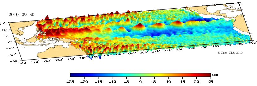
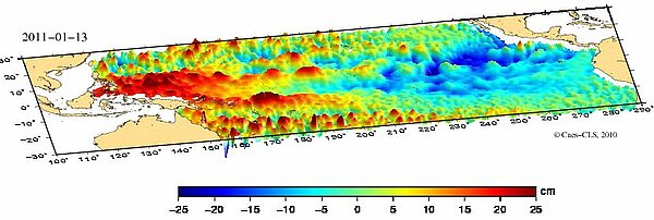
Sea level anomalies end of September 2010 (top) and mid-January 2011. The lower-than-normal sea surface height close to the coasts of South America are the signature of La Niña. On the opposite of the basin, high sea level anomalies can be seen close to Indonesia and the North of Australia, where heavy flooding are occuring. (see the movie for July 2010-January 2011 (mp4, 1 MB))
La Niña is no sweeter than its brother. Last year a not-quite El Niño was playing its last tricks at about this time. This year, a La Niña is wreaking havoc on the Eastern coasts of the central Pacific, and has still some stamina to stay on till Spring. Flooding is catastrophic in the Australian state of Queensland. Mud slides in Philippines are also numerous -- and so on.
The first "La Niña" observed by altimetry was by Geosat in 1988. Then we had to wait 1995 to see another one with Topex/Poseidon and ERS-1. Since then (since 1992, in fact), such phenomena are closely and continuously monitored by altimetry as well as by a wealth of other techniques, including the "TAO" array that dot Tropical Pacific with moored buoys. Thanks to all those, understanding of La Niña and El Ninõ is better and better, and the warnings are also improved.
Next altimetry satellites will continue to help improve both knowledge and warning systems, so as to be able to mitigate the effects of the erratic behavior of both climatic "children".
See also:
- Indicators: ENSO Index
ENSO maps (Sea Surface Temperature and Sea Level Anomalies) since 1993 - Applications/Climate: El Niño Southern Oscillation
Websites on this subject:
- Observations:
- CPC/NCEP (every Monday, sea surface temperature maps, subsurface analysis - thermocline variations - temperature/depth diagrams...
- Maps and sections from the TAO array
- Forecasts:
- Impacts on Australia:
- Australian Climate Extremes-Flood (Bureau Of Meteorology)

