177,000 eddies in the oceans
Image of the Month - March 2011
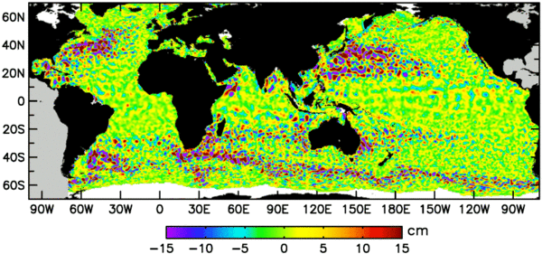
A map of sea level anomalies on 28 August 1996 where only the eddy-sized features were kept (large-scale features were filtered out) (top panel). Cyclonic and anticyclonic eddies are represented by negative and positive sea surface heights, respectively. More than 177,000 eddies, approximately equally partitioned between cyclonic and anticyclonic, were tracked for a time period of 4 weeks or longer over the 16-year time period October 1992 - December 2008.
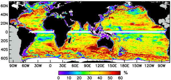
The percentage of mesoscale SSH variance accounted for by these eddies is shown in the middle panel.
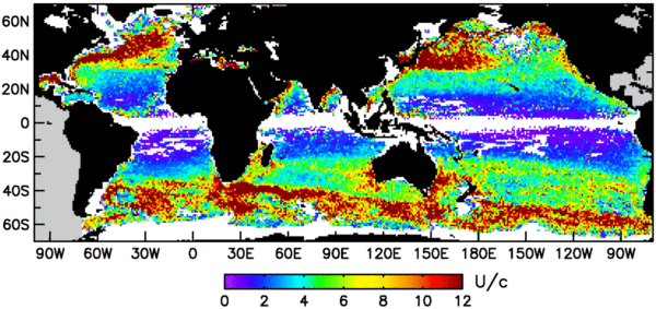
The bottom panel shows the average of the ratio of the rotational speed U of the eddies over the translation speed c, which was generally westward, except within strong eastward currents. When this ratio exceeds 1, there is trapped fluid within the eddy interior. This trapped fluid and its associated water properties such as heat, salt, nutrients and phytoplankton can be transported long distances by the eddies. For example, more than 13,000 eddies propagated westward over a distance of 500 km or more. (Credits Oregon State University)
Several studies tracking eddies have been shown here these past years. Now a dedicated dataset has been produced, for the 16-year period October 1992 - December 2008, thus enabling easy statistics and long-term studies. Better algorithms with respect to a previous global study (2007, see Image of the Month) enable to track twice as many eddies, especially long-lived ones (up to five times more eddies with life-span longer than one year).
This enables to show that most of the mesoscale features (i.e. sea surface height structures with radius of about 100-200 km) are "non-linear", i.e. that these features are coherent structures like eddies (as opposed to planetary waves that would be linear). Moreover, nearly all of those eddies can transport heat, salts and nutrients trapped within them (U/c metrics higher than 1, see bottom map) -- also as opposed to planetary waves that would not transport water parcels.
With high-resolution data obtained from combining the data from several altimetry satellites, even 'only' two of them (Topex/Poseidon with ERS-1 then ERS-2, Jason-1 then Jason-2 with Envisat), mesoscale features can be observed on the long term.
See also:
- Image of the Month, Sep. 2007: Altimetry on eddies' tracks
- Image of the Month, Jan. 2006: Merging of altimetry data: proofs from other measurements
- Applications: Combining sensors
- Data: Ssalto/Duacs near-real and delayed time multimission altimeter products
Websites on this subject:
- Mesoscale Eddies in Altimeter Observations of SSH (Oregon State University), with the "eddies" dataset to download
References
- Chelton, D. B., M. G. Schlax, and R. M Samelson, 2011: Global observations of nonlinear mesoscale eddies. Prog. Oceanogr., in press.

