Between Africa and Madagascar
Image of the Month - May 2011
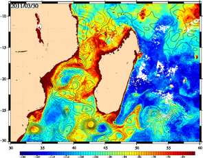
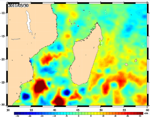
Maps of ocean color with sea level anomalies contours overlaid (left), and the map of anomalies alone (right) for March 30, 2011. Ocean color data have a high resolution. With the new high resolution altimetry dataset, the contours of the ocean topography quite closely match the one of ocean color (Credits Cnes/CLS)
The Mozambique Channel, between Africa and Madagascar Island, is one of the key area in the ocean circulation. A train of large anticyclonic eddies (with diameters over 300 km) propagates southward up to reach the Agulhas current, thus transporting heat and salt from the Equator. They influence the timing and frequency of Agulhas ring shedding, i.e. the fact that some eddies are shed from the loop of the Agulhas current South of Africa (see Image of the Month, November 2010).
To have a finer view on the ocean dynamic over the area, a new dedicated altimetry dataset was published end of March 2011, with an enhanced resolution with respect to the "classical" gridded data. Studies to improve altimetry data in both resolution and coastal areas are ongoing, that should also participate to better and better datasets and help both research and applications in the region. The future missions planned, like Saral (and its AltiKa altimeter) and Swot will also bring major progresses in the field.
See also:
- Data: <link en data product-information duacs index.html _self internal-link>Ssalto/Duacs near-real and delayed time multimission altimeter products
- Data: Mozambique area (M)SLA - (Map of) Sea Level Anomalies & geostrophic velocity anomalies
- Image of the Month, November 2010: Mixing Argo and altimetry to estimate salt
- Image of the Month, September 2010: ASAR vs altimetry South of Africa

