Lake heights and sizes from satellites


Lake Eyre in Australia, is a quite unusual lake. Very shallow, it fills only once in a while (water in black), and then evaporate till being empty, leaving a salt crust (in white) up till next flood that will fill it.In 2004, this series of event was monitored by satellites, with among others, Topex/Poseidon for altimetry (Credits Legos/Cnes)
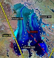
Altimetry ability to monitor lakes level has been demonstrated. However, an increased level can mean very different quantity of water depending on the extend of the stretch of water. Altimetry can't measure now such an extend, since its measurements are "limited" to its beam, directly underneath the satellite. However, other sensors -- imagery sensors -- enable to estimate the water surface area. Mixing altimetry and water surface area estimates give hydrologists the water volume needed to study lakes and reservoirs variations.
The Swot (Surface Water and Ocean Topography) mission will enable both type of measurements at the same time, with its wide-swath interferometric altimeter.