Malaria and altimetry in the Amazon
Human pressure on natural areas (deforestation, etc) influences the (re)mergence of vector diseases such as malaria, which are transmitted by insects or hematophagous mites (typically, all the diseases are transmitted by mosquitoes). Changes in vector populations are determined in part by water dynamics in the areas of flooding. This is why continuous monitoring of these areas, such as that which can be achieved using altimetry satellites, is so important in this context.
Methodologies have been developed for extracting data from 'virtual stations' (where the tracks of altimetry satellites intersect with bodies of water) in small bodies of water such as areas of flooding. Preliminary results were acquired in the Rio Branco basin and show the potential benefits of studying the dynamics of temporarily-flooded areas, and integrating these data into multi-criteria systems for monitoring epidemiological conditions in developing countries.
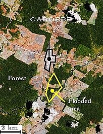
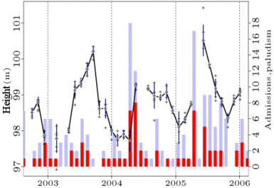
Water level variations measured by the Envisat satellite (black curve, left-hand scale) across a small area of flooding adjoining deforested areas, and hospital admission numbers (bar chart, right-hand scale) for infectious parasitic diseases including malaria (shown in red) for the nearest town, Caroebe (Brazil). A clear correlation can be seen between the water level and the incidence of infectious parasitic diseases: both follow an annual cycle and appear to be increasing over the longer term.
(Credits IRD).
See also:
- Image of the Month, October 2001: The Amazon under close surveillance
Websites on this subject:
- Hybam
- Cash project (Réseau Terre et Espace)
References:
- Roux E. et al., Effects of land and vegetation on the quality of satellite altimetric data for continental surface water monitoring. Remote Sensing of Environment (to be submitted).

