Ob bogs and wetlands
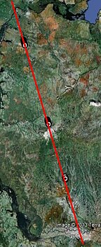
Saral (previously Envisat) track (left), and the backscatter coefficient measurements for (up) Saral first 3 cycles, (middle) Envisat in Ku and S band of the altimeter. Bottom, the topography of the area (Credits CNRS/Legos)
The North of the Ob River basin, in Western Siberia, is a vast region where permafrost is melting, creating particular landscape of bogs, thermokarst lakes, frost heaves and pingos. Saral, on the tracks of Envisat, enables us to look at this complex mozaic of water and dry areas. The backscatter coefficient (Sigma0) is the ratio between the power reflected from the surface and the incident power emitted by the onboard radar. Water and ice are good refectors, while dry vegetated areas strongly attenuate the signal. The attenuation depends on wavelength of emitted signal and increases from S to Ka band. The Sigma0 difference between wet/dry or ice/snow surfaces is higher for Ka band (see the Figure). This makes the Saral backscatter coefficient to be a better proxy to discriminate surface type within the radar footprint.
Saral, with the AltiKa altimeter onboard, has been launched late February by ISRO and CNES. It is giving very promising results (data are available since June 20th). Its smaller footprint (with respect to previously flown altimeters) is especially interesting for highly heterogeneous surfaces like wetlands.

