Sea ice
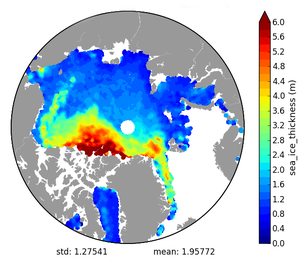
Sea ice is one of the least-known parameters needed for climate modelling. While its extent and age can be measured by other sensors, altimetry is the only one providing sea ice thickness.
Sea ice is seawater that has frozen. It contains little salt as most of it is rejected as it forms. Sea ice covers the Arctic Ocean more or less permanently above the latitude of about 75°N. This permanent ice cap is composed of pack ice, which is kept in continuous motion by the wind, tides and ocean currents. It must be noted that, since sea ice is floating, if it were to melt it would not cause the sea level to rise directly. However, due to its high albedo, ice directly affects the global Earth energy budget by reflecting about 80% of incident sunlight back out to Space. Thus, once formed, ice tends to be maintained. However, if ice cover were to decrease, less solar radiation would be reflected away from the surface of the Earth - causing the ice to absorb more heat and consequently melt faster still. The thickness of Arctic sea ice also plays a central role in the polar climate as it moderates heat exchange by insulating the ocean from the cold polar atmosphere. Moreover, as sea ice forms, the salinity, and therefore the density, of the upper ocean increases. This density increase causes the surface waters to sink - in essence acting as a pump, driving cold, deep ocean currents from the polar regions towards the equator.
In the Arctic, sea ice typically covers about 14 to 16 million square kilometres at its maximum extent in late winter (March), and ~4 to 8 million km2 (3.4 millions km² on 2012) at its minimum seasonal extent in late summer (mid-September). In the Antarctic, sea ice at its maximum covers 17 to 20 million square kilometres on September and only about 2.6 to 3.5 million square kilometres at its minimum on February. Observations show that the mean Arctic ice extent is decreasing at a rate of about 3% per decade while Antarctic ice extent is quite stable.
Regional sea ice models have been successfully developed over the last decades. However, given the impact that sea ice has on the climate, it is essential to acquire more comprehensive data on sea ice thickness, in order to improve sea ice models for their implementation in general climate studies.
One method of computing sea ice thickness is based on the difference in height between sea and ice surfaces, allowing this parameter to be acquired from altimetry. A careful analysis of individual echoes can distinguish between those backscattered from the open ocean, new ice or multi-year ice. The difference between the elevation of the echoes from snow/sea ice and open water then gives the elevation of the ice above the ocean; the ice thickness can thus be deduced from this.


