
Ocean Seasons in the Mediterranean Sea
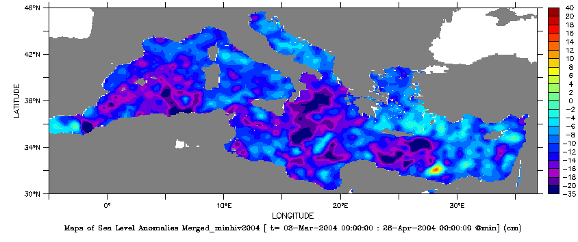
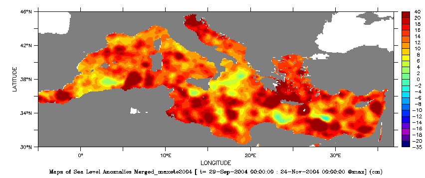
The sea surface dynamic topography is directly related to the ocean currents. To map the circulation, combining altimetry data (here Topex/Poseidon and ERS-1) improves the time-space sampling. Thus, for the first time, the main features of the Mediterranean circulation, especially the seasonal variations, are being observed through altimetry. The mapping of the sea level anomaly (with respect to a mean) shows a strengthening of the ocean circulation during winter, probably due to changes in wind forcing.
These results will be very useful for validating Mediterranean sea models. The altimeter data will soon be assimilated into the models to constrain the three-dimensional circulation.
Mean sea level variations in the Mediterranean

Thanks to altimetry data, we have been able to observe trends in the Mediterranean mean sea level for the first time. The amplitudes are large, around 20 cm, with a maximum in October-November, a decrease in January-February, and a minimum in March. Half of this signal is due to steric effects, i. e. contraction and dilation of the surface waters resulting from heat fluxes at the ocean-atmosphere boundary layer. The remaining signal is probably due to an imbalance between the in-flow / out-flow at Gibraltar, evaporation and precipitation.
Thus these results suggest that, on a seasonal scale, the Mediterranean water mass is not exactly conserved. Continuous monitoring of the mean sea level, and thus of the water mass budget will be a very valuable indicator of climatic changes around the Mediterranean.
Further information :
- Image of the month, September 1999 : Mare nostrum, Mare incognita ?
- Lively Data, November 19, 2007 : <link fr donnees data-access-services live-access-server-las balades-en-las index.html _self internal-link>Mediterranean seasons.

