Digging into the data
Lively Data : September 8, 2003
Now that we've been playing with the LAS for some time, let's have a look at what's behind it. It is in fact a database, called "OpendDap", available at http://opendap.aviso.oceanobs.com/. If you go there, you will see all the datasets available with this LAS, with "Data Request Form", that able you to choose and download a time-serie over your favorite area of study. However, we recommend that you use this OpenDap through your favorite interface / programming language. See:http://www.opendap.org/faq/whatClients.html for adaptated clients.
OpenDap (or DODS: Distributed Oceanographic Data System) is a framework that simplifies all aspects of scientific data networking. OpenDap provides tools (see: http://www.opendap.org/faq/whatServers.html) for making local data accessible to remote locations regardless of local storage format. OpenDap also provides tools for transforming existing applications into OpenDap clients (i.e., enabling them to remotely access OpenDap served data, see: http://www.opendap.org/faq/whatClients.html).
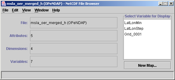
For example, with NCBrowse, a tool to browse NetCDF files (see Epic website to download it):
When you open the software, you can choose to use an OpenDap in the "File" menu. Then, you can enter the URL, e.g. for Ssalto/Duacs merged MSLA data:

(see at http://opendap.aviso.oceanobs.com/ for other datasets' URLs)
You then have three variables you can display:
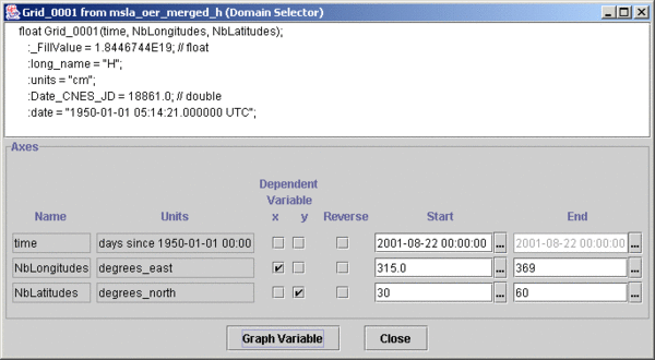
Choose "grid001" by double-clicking on it (for geostrophic velocities, grid001 contains U, Grid002 V). Then, you can choose whichever variable (Time, lon, lat) you want as x and y:

(default is time-longitude)
You can change to longitude as x, latitude as y, and then choose your area:
And, finally, by clicking "graph variable", you have this map (blank areas are continents):

 Use the Live Access Server

