Mediterranean animated currents
Lively Data: March 14, 2008
The latest version of the LAS (7.+) enables a new data representation, very useful to highlight the evolution of a variable over time: animated images.
To introduce this new option, the example chosen this month is located in the Mediterranean Sea. The Absolute Dynamic Topography (ADT) represented over a 5-months period (July-November 2004) underlines the mesoscale circulation in this enclosed sea basins.
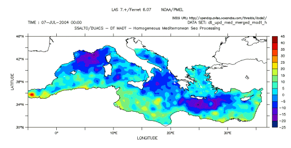
Absolute Dynamic Topography (ADT) in Mediterranean Sea between the 7th of July and the 24th of November, 2004 (one date at each image). Choose DT - Delayed time Data > Mediterranean > (Maps of) Absolute Dynamic Topography then longitude-latitude map in select view and "Animation" in select output. Finally, select the middle of the chosen period (here its the 15th of September 2004). From this choice, the LAS automatically sets the beginning and the end of the period (10 dates before and 10 dates after the 15th of September). The animation is appearing on a new window from an external link where you can select the projection speed.
The Mediterranean Sea shows a complex circulation, which is characterized by a high spatial and interannual variability in each sub-basin: Alboran Sea, Algerian basin, Tyrrhenian basin, Balearic Sea, Ionian Basin, Aegean Sea, Levantine basin.
The two regular eddies of the Alboran Sea (1 ° W, 36 ° N) are visible over the almost whole period. Off the Algerian coasts, the animation shows the evolution of several eddies detached from the Algerian current which it flows along the coast. In the Tyrrhenian basin (between Corsica-Sardinia and Italy), the Absolute Dynamic Topography clearly shows the presence of the intermittent Bonifacio cyclonic gyre, centered near 41.5 ° N between late August and early November. In the Levantine Basin, South of Crete, the seasonal activity of the Ierapetra gyre is detected from late August and continues until the end of the period represented, in November.
Further information:
- Data : Absolute Dynamic Topography (ADT) in Mediterranean Sea.
- Pujol M.-I., 2006, "Analyse de la variabilité de surface en Méditerranée à partir des données altimétriques et comparaison aux simulations MERCATOR et MOG2D", Thesis from University Paul Sabatier, Toulouse III.
- Mediterranean Sea related-links on Aviso website.
 Use the Live Access Server

