Fierce gale for the Vendée Globe fleet
Lively Data: November 20, 2008
The 2008 edition of the Vendee Globe is launched. From the Bay of Biscay, to intrepid howls of fifties, the road to the South is long: storms, soft Easterlies, Doldrums, changing currents, ... The LAS can help us to imagine the real conditions faced by lonely sailors.
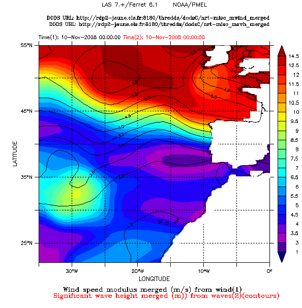
A violent storm in the Bay of Biscay was a spoilsport just a day after the start, forcing several sailors to return towards the port and forcing some of them to retire. A map of wind speed modulus and significant wave height from merged altimeter data on the november 10, 2008 shows the extent and the intensity of this front: winds over 12 m / s (or ~ 23 knots) and waves up to around 5 m in the Bay of Biscay, the worse conditions being located to the west and north-west of Ireland. Meteorological measurements showed gusts up to 28 m / s (55 knots).
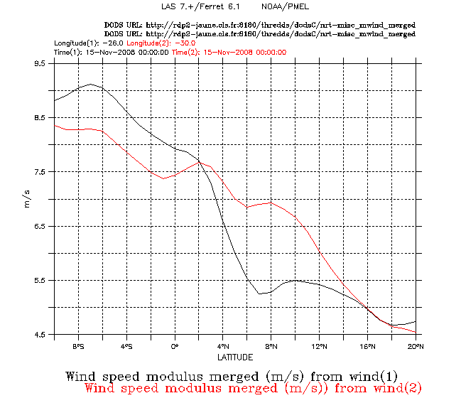
After eleven days at sea, it's the vicissitudes of Doldrums to be a spoilsport. The location of the intertropical convergence zone moves around the equator and is feared by sailors for its erratic changes. For now, the sailors seem stick in an area with several passages without wind. A map of the wind speed modulus averaging over the winter 2007-2008 shows the location of this contrasted area around the equator. A transect on the 26 ° W meridian (it's almost the path taken by the boats since the islands of Cape Verde) made from the wind data on the November 15, 2008 indicates latitudes with less wind: the wind is below 5 m / s up to latitude 6 ° N. This area crossed, the wind should swell the sails. A transect made further west, on the 30 ° W meridian, shows that the situation is quite different, with more winds.
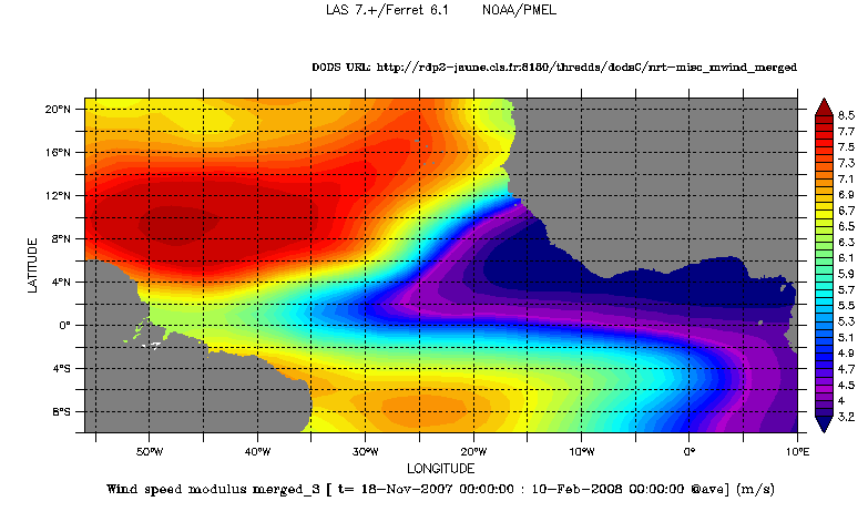
Left: Wind speed modulus averaged (m/s) over the period November 2007 - February 2008. Choose NRT - Near-real time Data, Global, (Maps of) Wind Speed Modulus merged. Click on Define variable to calculate the average, tick off "T" in Apply to these axes and define the period. The black and white lines has been added to locate the curves, on the right.
Right: Wind speed mdulus vs latitude following two longitudinal lines : 30°W in red and 26°W in black.
Further information:
- Applications: Winds and waves.
- Vendée Globe, official web site of the race.
 Use the Live Access Server

