Seasonal reverse in the Somali current
Lively Data: January 26, 2010
Along the Somali coast, the seasonal circulation changes drastically with a spectacular reverse in the Somali current. In this part of ocean, winds and currents (atmosphere and ocean) are strongly coupled. The circulation variations are due to changes in the wind stress associated with the Indian monsoon.
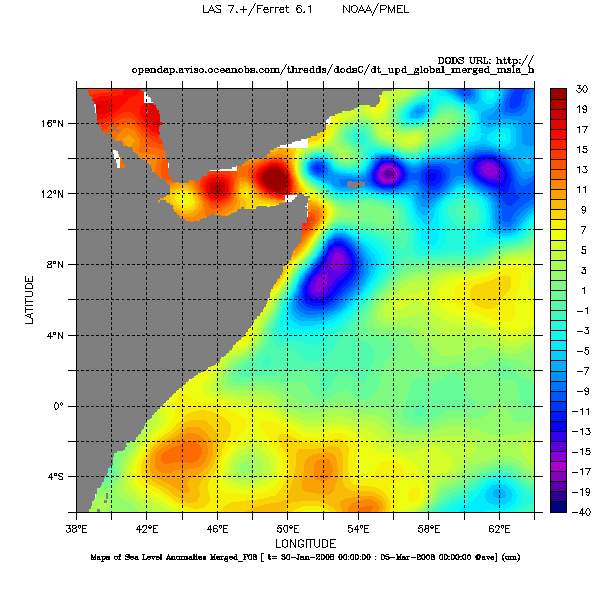
During winter, winds flow southwestward in the northwestern Indian Ocean. During this Northeast monsoon (also called the Winter monsoon), the winds drive a southwestward boundary current along the coast of Somali.
Top: Merged maps of Sea Level Anomalies (in cm) averaged on February 2008 in the northeast part of Indian Ocean. To made a such map with the LAS, choose DT - Global - (Maps of) Sea Level Anomalies Merged. In Define variable, choose Average, "T" then the reference period (2008/01/30 - 2008/03/03) . Click on Next then select the area 38°E/64°E/6°S/18°N.
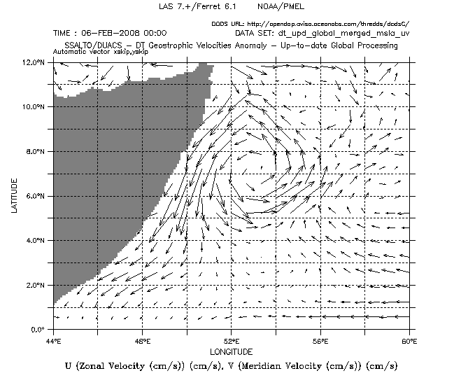
Below: Maps of Geostrophic Velocity Anomalies cm/s the February 06, 2008, off the Somali coast. . Choose DT - Global - (Maps of) Geostrophic Velocity Anomalies , Variable(s): Vector (U,V), the date, and the geographical area.
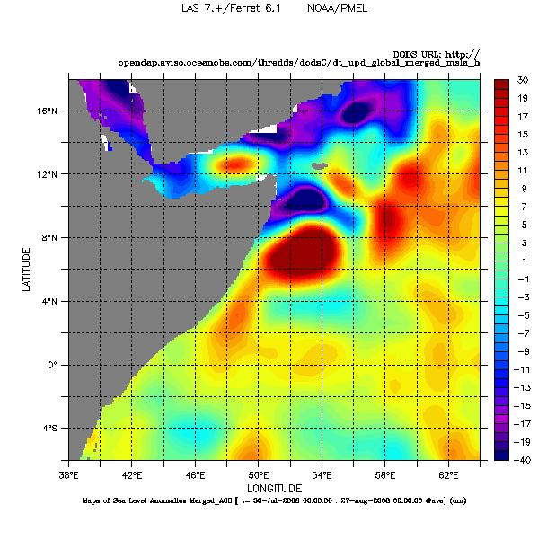
During the Southwest monsoon in summer, winds flow northeastward and drive a northward flow all along the Somali coast. As a consequence of the Coriolis force, Ekman transport shifts these upper warm waters offshore permitting upwelling of cooler waters along the coast. The difference from the previous map is immediately obvious.
The configuration of the Somali current during this Southwest monsoon comes close those of western boundary currents. On this account, the Somali Current is the analogue to the Gulf Stream in the Atlantic, and Kuroshio in the Pacific. But, unlike them, the western boundary current for the northern Indian Ocean is only present part of the year.
Top: Merged maps of Sea Level Anomalies (in cm) averaged on August 2008 in the northeast part of Indian Ocean. To made a such map with the LAS, choose DT - Global - (Maps of) Sea Level Anomalies Merged. In Define variable, choose Average, "T" then the reference period (2008/07/30 - 2008/08/27) . Click on Next then select the area 38°E/64°E/6°S/18°N.
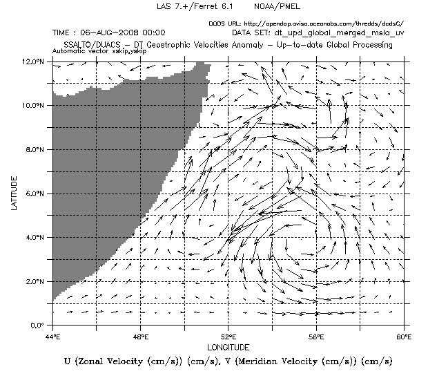
Below: Maps of Geostrophic Velocity Anomalies cm/s the August 06, 2008, off the Somali coast. . Choose DT - Global - (Maps of) Geostrophic Velocity Anomalies , Variable(s): Vector (U,V), the date, and the geographical area.
Further information:
- Image of the month:
- August 2004 : Summer : wet monsoon season.
- Oct. 2002: Summer current, winter current
- Lively Data:
- May 23, 2005 : <link en data data-access-services live-access-server-las lively-data may-23-2005-looks-on-indian-monsoon index.html _self internal-link>Looks on indian monsoon.
- August 28, 2006: A breath of air in Arabian Sea
 Use the Live Access Server

