Surface circulation in the Eastern Mediterranean basin
Lively Data, July 22, 2010
The Eastern Mediterranean basin, also called Levantine Basin, is located at the East of Crete Island. As the general circulation in the entire Mediterranean Sea, the circulation in this basin is induced both by winds at surface and water density differences.
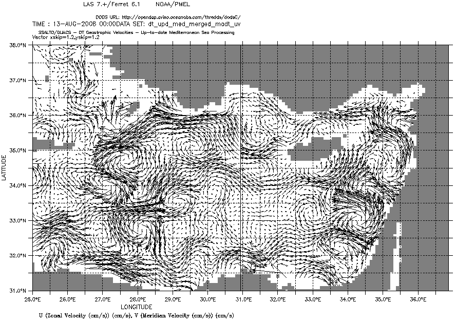
At the entrance of the Levantine basin, around 25°E, the Mid Mediterranean Jet (MMJ, in red on the map) departs from the African coast. It flows easward between 3 eddies more or less stable, not permanent. These features are visible on a map of geostrophic currents made with the LAS on 2008/08/13.
- the Rhodes cyclonic eddy (blue "R" letter on the map)
- the Mersa-Matruth anticyclonic eddy (orange "MM" letters on the map),
- the Shikmona anticyclonic eddy (orange "S" letter on the map).
The MMJ passes south of Cyprus, bifurcates generally to the north and enters the Lattakia (off Syria) and Cilician (between Turkey and Cyprus) sub-basins. In this latter sub-basin, the MMJ moves westward and becomes the Asian Minor Current (AMC, in green on the map). It flows up to Rhode Island between smaller scale cyclonic and anticyclonic eddies and transfing warm and salty waters to the west.
The seasonal variability shows two extreme patterns: one in winter, the other in summer. While an overall strong coastal circulation can be seen in winter, the summer circulation is dominated by high mesoscale variabilities.
Further information:
- Lively Data:
- August 21, 2007: The Alboran eddies
- January 16, 2009: Global product vs Mediterranean product
- June 18, 2009, Meddies in Atlantic Ocean
- March 14, 2008: Mediterranean animated currents
- March 20, 2009: Variability of Mediterranean Sea
- November 19, 2007: Mediterranean seasons
- Applications : Mesoscale circulation
- Altimetry applications in videos : Mediterranean Sea
- B. Alhammoud et al.: Long life for the Eastern Mediterranean mesoscale eddies. Ciesm congress, 2007. See the abstract in pdf.

