Gulf Stream variability
Lively Data, June 10, 2010
The LAS is not only a graphical interface; it can also compute statistics over data.
The Gulf Stream is a turbulent western boundary current with strong variations caused by an intense eddying. By representing the sea level anomalies variance (or standard deviation - or rms - which is calculated by the root square of variance) over September 2003- July 2009 (which is the follow-on on the Lively Data shown in October 2003: Variance), strong, medium and low variability areas are described throughout this area.
Variability ranges between 3 and more than 20 cm rms. The highest variability which can be as much as 35 centimeters, is located along the northern boundary of the Gulf Stream.
The strong variations in these zones are caused by intense eddying generated by instabilities in this powerful ocean current.
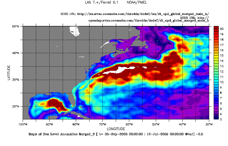
Merged Sea Level Anomaly rms in the Gulf Stream area over September 2003 - July 2009. To plot such a map, you have to select the dataset Delayed-time, the global product, the variable (here Maps of Sea Level Anomalies Merged), and afterwards click on the left menu on "Define variable". You have the choose between "average", "minimum", "maximum", "sum" and "variance". So, we choose the variance and the period as defined above. Then click on "next" in order to fill in land areas and calculate the rms: in evaluate expression, we note $^0.5 to tranlate rms=√(variance). The color fill levels is (0,20,0.5)(35) in order to highlight in white the highest values. The variance map is available by clicking here.
Further information:
- Applications: Variability of ocean circulation
 Use the Live Access Server

