Screencast tutorial for the new LAS version
Lively data, 14 August 2012
As you may have noticed, the new LAS interface installed with the new version (see our news) significantly differs from the previous one. We are pleased to propose new Lively Data with new practical examples to get hand's with new buttons, new options, ... And because some pictures are better than a long speech, we propose the Lively Data as a screencast tutorial, where each step is directly described by markers on the interface. So, play the sequence below and try to do yourself. Click on the video to stop the sequence. If you prefer written instructions, read the main steps in the caption at the bottom of the video screen.
What's observed ?
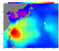
Saola typhoon first formed as a tropical depression over the western Pacific Ocean by the end of July 2012. Then it strengthened into a typhoon (category 2, 130 km/h) and caused severe rains and flooded the Philippines, Taiwan and southeast China.
Which data ?
Ssalto/Duacs global, merged Significant Wave Height in Near-Real Time deduced from altimetry and integrated in the LAS can help to highlight the large areas with waves values exceeding 5 m.
Which LAS options?
Map on a given area and for a given date. Color fill levels and land filled style are customized.
ERROR: Content Element with uid "9367" and type "media" has no rendering definition!
Play the screencast tutorial to learn how to plot a map of Significant Wave Height over the Pacific Ocean, for a given date (2 Mb, optimized for 720x540). Choose a dataset (NRT-Global-Near Real Time Significant Wave Height), select the date (2012/08/01) and the region named (North Pacific). Update Plots and Set plot options to custom the color fill levels and highlight the Saola typhoon. Credits Cnes/CLS.
Further information:
- Lively data : Aug. 2009: Severe typhoon Morakot in the western Pacific
- Image of the month: Aug. 2007: Altimetric views of a typhoon
- Applications:
 Use the Live Access Server

