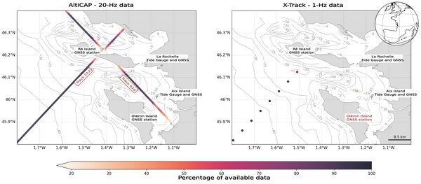
Altimetry measures close to the coasts of La Rochelle
Image of the Month - July 2025
Coastal altimetry is a complex topic - the radar beam can reflect on a mix of water and land, thus the data must be processed differently from the open ocean --. Moreover, the coastal dynamics involve tides, potentially extremely jagged coastlines. The "high-resolution" along-track data ("20 Hz") are needed to get as close as possible to the lands. Cnes/CTOH/Legos/CLS/Noveltis published a new dataset last year, AltiCap, with 20-Hz dedicated processed Sea Level Anomalies "close" to the coasts (less than 500 km), from Jason-3 only for now.
A study made in the frame of a PhD at La Rochelle Université (west of France, on the coasts of the Bay of Biscay) is looking at those data in their neighbourhood. The "pertuis charentais" is a shallow area between the coast around La Rochelle proper and the islands (Ré, Aix and Oléron islands) with complex currents and tides. A number of in situ stations are available there (La Pallice (La Rochelle) and Aix Island tide gauges, GNSS station at Ré and Oléron Islands), some for a long time, which enable to validate the altimetry data. The study aims to extend the time series to other altimeters, on the "reference mission" historical track (Jason-1 & 2, Sentinel-6 Michael Freilich), but also others missions overflying the area (Sentinel-3A, Saral), and Swot nadir.
See also:
- Appplications: Coastal applications
- Data: AltiCap and X-Track products
- Technique: altimetry close to the coasts: technical issues and solutions
References:
- Vignudelli, S., Kostianoy, A. G., Cipollini, P., & Benveniste, J. (Eds.). (2011). Coastal altimetry. Springer Science & Business Media.
- Léger, F., Birol, F., Bignalet-Cazalet, F., Cancet, M., Dagneaux, Q., Daguze, J. A., ... & Tolu, L. (2024, April). Towards an operational global coastal altimetry product: AltiCAP (ALTimetry Innovative Coastal Approach Product). In EGU General Assembly Conference Abstracts (p. 8206).
- Birol, F., Fuller, N., Lyard, F., Cancet, M., Nino, F., Delebecque, C., ... & Léger, F. (2017). Coastal applications from nadir altimetry: Example of the X-TRACK regional products. Advances in Space Research, 59(4), 936-953.


