Since the 1990s, an in situ observation system has been set up in the Pacific and new satellites have continuously scanned the global ocean. The 1997-98 El Niño was the first closely monitored event. The Topex/Poseidon mission showed that precise satellite altimetry reveals the general features of an event several months ahead.
These observation systems contribute to testing and refining our knowledge of ocean-climate interactions and numerical models of the climate. For the first time, climatologists have produced global-scale seasonal forecasts. Though we cannot avoid El Niño's whims, we can predict and mitigate its impacts.
Setting up an alerting system is important for all phases of natural hazard management, from outreach and education to preparing for danger. The ultimate goals are to:
- protect human populations from floods and diseases,
- better manage forests, energy resources and farmlands (e.g. by developing drought-resistant crops),
- help fish farming, aquaculture and deep sea fisheries (e.g. by surveying stock quantities and distributions).
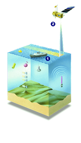
The in situ observing system (1) includes a network of meteorological/oceanographic buoys moored to the seafloor, measuring ocean surface atmospheric and subsurface conditions. Drifting buoys measure temperature and currents. Some merchant ships are also fitted with scientific instruments which measure temperature profiles. Most of the data are sent in near-real time via the Argos system.
To obtain a global view of the Pacific, oceanographers use altimeter measurements (2). These provide an accurate index of surface variations, sea surface currents and changes in ocean heat content.
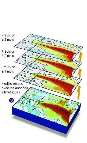
Scientists use all these high-quality measurements to better constrain prediction models (3), adjusting conditions in real time to converge on reality.
Video produced by CNES. Mira Productions executive, October 2016
El Niño is a cyclic event. The Topex/Poseidon and Jason satellites have observed and studied the 1997 El Niño, the subsequent milder episodes of 2002 and 2007, and the 2015 event comparable in strength to 1997. In all, it’s thought that 60 million people were affected by extreme climate events in 2015-2016.
It’s hard to know for sure whether the many effects observed on global climate were due to El Niño, a changing climate or both. The central and eastern Pacific Ocean has become hot and humid. Heavy rains have brought flooding to American coastlines, although with less impact than in 1997 because the event was less pronounced nearer to shore. Meanwhile, the weather in the western Pacific has become drier. In Indonesia and Papua New Guinea, drought conditions have stoked forest fires, albeit less severe than in 1997 when a record 2 million hectares of forest went up in smoke.
We don’t yet have enough data to analyse all of the climatic consequences of an El Niño and attempt to predict them. Is climate change interacting with El Niño and if so to what extent? As the planet warms, will El Niño episodes get more frequent and intensify or more scarce?
In this long quest to observe, understand and predict El Niño and its influence on climate, operational oceanography and altimetry satellites are going to prove vital.
Further information :
- Image of the month, December 2000 : Climate prediction systems cut their teeth on El Niño.


