The 2011 Japan Tsunami
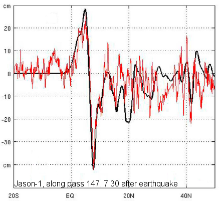
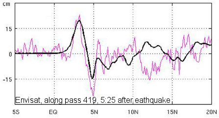
On 11th March 2011, a 9.0- magnitude earthquake off Japan's north-eastern coast generated a huge wave which, breaking on the shore, devastated everything in its path. Three altimetry satellites (Jason-1, Envisat and Jason-2) observed the front wave over the Pacific Ocean between 5 and 22 hours after the earthquake. Envisat detected the first wave front 5 hours and 25 min after the earthquake with a trough-to-crest amplitude of more to 30 cm. Jason-1 measured a larger amplitude (>60 cm), 7 hours and 30 min after the earthquake.
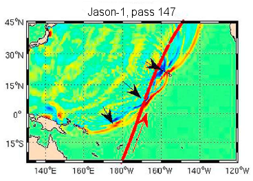
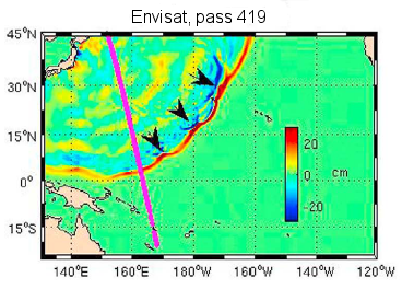
Top: Ground tracks Jason-1 pass #147, at 7:30 hours after the quake (left) and Envisat pass #419 at 5:25 hours after the quake (right), overlaid by a wave propagation simulation at the time of the satellite's passage.
Bottom: Model tsunami (black lines) with the satellite altimetry data along the passes, respectively, Jason-1 (left, in red) and Envisat (right, in pink). Credits T.Y Song (2012, Geoph.Research Lett.).
Further information:
- Altimetry applications in videos: Tsunamis.
- Image of the month: January 2012, Tsunamis debris on the Pacific
- Newsletter #6, April 2011: Tsunami observation by altimetry
- Nasa Earth Observatory website, animation of the wave propagation of the 2011 Japan tsunamis (2012): The Seafloor Focuses and Merges Tsunami Waves
- Okal, E., A. Piatanesi, and P. Heinrich, Tsunami detection by satellite altimetry. J. Geophys. Res. 104 (B1), 1999.
- Song, Y. T., I. Fukumori, C. K. Shum, and Y. Yi (2012), Merging tsunamis of the 2011 Tohoku-Oki earthquake detected over the open ocean, Geophys. Res. Lett., 39, L05606, doi:10.1029/2011GL050767.
- A brochure about tsunamis : Tsunami, the great waves, written by the International Tsunami Information Center (ITIC).
- Preparing for Tsunamis in the Mediterranean, Tsunami warning and mitigation system in the Northern Atlantic and in the Mediterranean Sea. Video (8 min) from UNESCO-IOC, in the context of NEAMTIC project.

