The 2022 tsunami in the Pacific Ocean (Hunga Tonga volcano eruption)
The Hunga-Tonga submarine volcano produced a very violent explosion on Saturday 15/01/2022 at approximately 04:15 UT (17:15 local time). The explosion generated a tsunami affecting all the Pacific Ocean. The tsunami chronology is described accurately on the CEA web site (in French).The tsunami has been detected in the multimission (Duacs) operational Sea Level products ingesting the flying altimeters Jason-3, Sentinel-3A, Sentinel-3B provided by Eumetsat, Cryosat-2, Saral, HY-2B provided by Cnes. The Duacs system is the backbone of the Sea Level thematic Center of the Copernicus Marine Environment and Monitoring Service, and provides in real time, the Sea Level for a wide range of ocean applications. Although the service is not specifically designed for tsunami detection, the altimetry measurements with a dedicated processing has the potential to detect the tsunami.
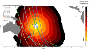
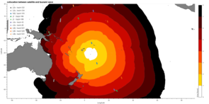
A preliminary estimation of the tsunami propagation through the Pacific Ocean is plotted and superimposed with the 10 altimeter tracks (from 5 different satellites) flying over the area between 4:15 UTC and 12:00 UTC. The Chinese satellite HY-2B satellite is the first to fly over the area 1h30 after the eruption. Other satellites (Cryosat-2, Jason-3, Sentinel-3A & B, also crossed the area but more than 4 hours after the event -- Sentinel-6 Michael Freilich is not cited here since it is providing about the same measurements than Jason-3 at this stage). To highlight the tsunami signal, the variability of the ocean has to be removed using the gridded multimission Sea Level Anomaly (SLA) map. A specific map has been computed from the along-track data without the tracks having measured the tsunami.
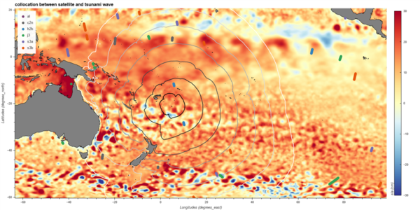
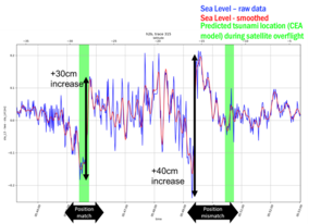
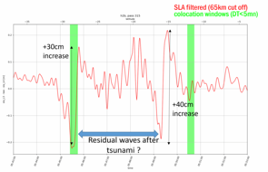
At 28°S, close to the expected position, HY2B measures a -20cm low elevation followed again by a sharp (+35 cm) increase. Then between [28°S-16°S] HY-2B measures a series of waves up to 25 cm crest to trough and with a 20-40 km wavelength. This section is supposed to be measured after the passage of the tsunami. At 16°S a -20cm low elevation is again observed followed by a sharp (+40 cm) gradient. The expected position of the tsunami was ~12°S.
The 30-40 cm sharp SLA gradient and short wavelength signals measured by HY-2A seem to be the signature of the tsunami measured 1.5 hour after the event start. The North tsunami is not where it was expected by a simplified model. Comparison with more elaborate simulation must be performed. These altimetry data will be valuable independent data to assess tsunami models.
The capture of the tsunami event by the constellation of altimeters show their complementarity and their sampling, and the great interest of contributive missions in general and the HY-2 series in particular, for the analysis of the small scales signals of the ocean.
