
Tehuantepec eddies
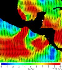
In winter, winds blow by pulses through a mountain pass across the Tehuantepec Isthmus (Mexico) to fan out over the Mexican Pacific in the center of the Gulf of Tehuantepec, generating large mesoscale eddies. In situ observations reveal strong cooling of the ocean below the axis of the wind, accompanied by the development of an offshore current jet that quickly evolves into a large anticyclonic eddy.
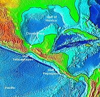
Topography of the Tehuantepec area (left), and winds both sides of the isthmus, as measured by scatterometers (right). Winds from the Gulf of Mexico cross the isthmus through the Chivela Pass, narrow and much lower than the surroundings, thus creating a jet wind. (Credits Noaa (topography) and <lk> Coas</lk> (wind map)).

Altimetry measurements, confirmed by drifter observations, show that these eddies propagate offshore at about 9 km per day, initially southwestward and later more westward. Their sea-level signature can be tracked as far as 140ºW before it disappears during the summer (the eddy season begins in late October and lasts approximately 250 days until early July), coinciding with the strengthening of the North Equatorial Countercurrent. More than twelve years of altimetry data show that five to six eddies are generated on average off the Gulfs of Tehuantepec, Mexico and Papagayo (Nicaragua) each year, and form a band of mesoscale activity between 10 and 12°N extending from 120°W to the coast. Such ocean features have a large-scale impact on the Eastern Pacific.
Further information :
- Tehuantepec eddies as seen by altimetry on Google Earth (Download the kml file and open it in Google Earth).
- Image of the month :
- November 2006 : Argonautica buoys around a Tehuantepec eddy.
- August 2006 : Tehuantepec eddies: a multi-sensor's view on biology

