CTOH Eddy Tracking
A technique developped at the CTOH / LEGOS, in collaboration with the CSIRO, Australia, to track mesoscale eddies using the Okubu-Weiss parameter.
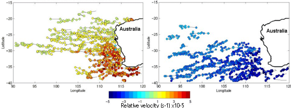
Satellite altimetry can be used to study the propagation pathways of warm and cold ocean eddies in different ocean basins.
We have developped an eddy tracking technique that follows eddies that have a life span longer than 3 months as they cross different ocean basins. Some of these mesoscale eddies can exist for many years. We have worked on three regional studies: in the southeast Indian, the southeast Atlantic, and the northeast Pacific Oceans.
The case studies show that simple theories for vortex propagation on a beta-plane work in regions where energetic eddies propagate though a weak background flow. Under these conditions, anticyclonic eddies tend to propagate westward and equatorward, whereas cyclonic eddies tend to propagate westward and poleward.
Detecting and Monitoring Ocean Eddies
Our main problem is how to systematically identify individual mesoscale ocean eddies from a series of altimetric SLA maps. Following Isern-Fontanet et al. [2003], we define the eddy cores as regions in which the second invariant of the velocity gradient tensor is positive. We can express this in terms of a parameter, Q, which is based on the 2D velocity field, (u, v) derived from>the altimeter SLA maps assuming the geostrophic approximation.
Assuming that the vorticity and the strain are slowly varying with respect to the vorticity gradient along a particle path, the term Q measures the relative contribution of the flow rotation and its deformation. For Q > 0, the rotation dominates the deformation. A vortex exists in regions where Q is positive and relatively large, Q > Q0. In our case studies, we tested various threshold values for Q0.
Initial tests in the southeast Indian Ocean revealed a large number of eddies were selected using the Q > Q0 criterion, especially near the coast and in regions of low eddy energy where the signal-to-noise ratio is low. In order to select the larger amplitude, long-lived eddies, we added a criterion that SLA > H0 for anticyclonic eddies, SLA < H0 for cyclonic eddies. The eddy lifetime is >90 days and >120 days in the Agulhas.
We developed an automatic tracking technique to monitor the eddy propagation. All eddies with Q > Q0 and SLA > H0 are identified in the initial map at time, t0. We then search for the same eddy structure within a spatial radius, R, around our initial eddy position in the next map at time t0 + 10 days. Since the propagation speed of these mid latitude eddies is a few km per day, the search radius R is set at 1 deg. We also identify new eddies in each new map. Sometimes the eddy structures weaken or disappear between consecutive maps if they pass into the gaps between satellite groundtracks. To minimize this problem, we keep searching for the same eddy for 20 days after it ‘‘disappears’’.
References :
- Morrow R. A, F. Birol, D. Griffin and J. Sudre, 2004. Divergent pathways of cyclonic and anti-cyclonic ocean eddies, Geophys. Res. Lett. 31, L24311, doi:10.1029/2004GL020974.
- Isern-Fontanet, J., E. Garcia-Ladona, and J. Font (2003), Identification of marine eddies from altimeter maps, J. Atmos. Oceanic Technol., 20, 772–778.


