Kuroshio and Gulf Stream
Lively Data : June 17, 2005
Absolute Dynamic Topography is the sum of two factors:
- the first one concerns mean currents and represents a stationnary component of total current (Mean Dynamic Topography, MDT)
- the second one is the variable component of total current (Sea Level Anomaly, SLA)
Observing oceanic variability (e.g Absolute Dynamic Topography's variance) within North Pacific and Atlantic basins via the LAS is an interesting way to show Kuroshio and Gulf Stream. Kuroshio and Gulf Stream are western boundary currents known for their similar properties: both flow towards the east-side of the basin, respectively American coast and European coast, and serve to warm these continents.
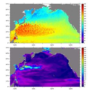
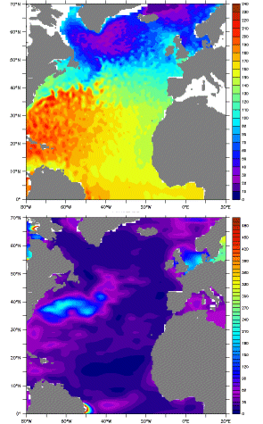
Mean Dynamic Topography and Sea Level Anomalies variance, computed from 2001 to 2005 in North Pacific and Atlantic oceans.
Mean Dynamic Topography (MDT) is obtained by computing the difference (MADT-MSLA), use "compare two" then choose the "comparison plot" option; date doesn't matters because MDT is stationnary.
To compute variance, choose "MSLA low resolution" as dataset (avalaible in Near Real Time) then select "define variable", "variance" and finally "t" as the variable.
Variance computing using MADT on such a period is complicated because of the time needed for, which is too long. Besides, computing variance using SLA and ADT is the same, because MDT doesn't vary with time.
On bottom maps, variance shows these currents crossing their basins.
See also :
- Image of the month, June 2000, "Lively currents", a map presenting ocean variability at a global scale, using combined data over 6 years.
- Lively data, December 15, 2004 "What's behind "MADT"" , and June, 15, 2004 "SLA vs ADT" also provide information about differences between Sea Level Anomalies and Absolute Dynamic Topography.
 Use the Live Access Server

