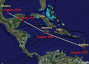
Trajectory of Hurricane Dean
Lively Data : October 2, 2007
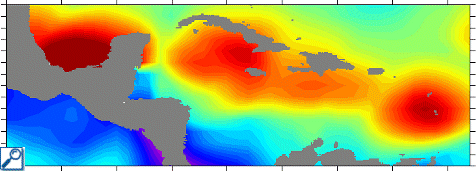
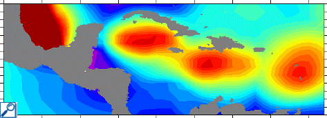
Initially classified as a tropical storm during its formation off the Cap Verde on August 13, 2007, the hurricane Dean crossed the West-Indies between the 16th and the 17th of August while being classified category 3 on the Saffir-Simpson scale. It finished its trajectory on the Mexican coasts of Yucatan on 22 and 23 of August while being classified category 5 with winds blowing faster than 260 km/h. Violent winds, strong swell and heavy rains were measured in the area. The maxima wind speed and significant wave height over the period between the 14th and the 24th of August, computed with the LAS from altimetry data, not only make it possible to see forces motion but moreover to plot the trajectory of Hurricane Dean. Between the 14th and the 24th of August, the centers of the swirls drawn with the LAS, which correspond to the maxima wind and wave values, are very well correlated with the moving of the cyclone.

By estimating wind speeds and wave heights but also by identifying anticyclonic eddies where the cyclones may intensify, altimetry satellites improve significantly their predictions.
See also :
- Applications: Hurricane Katrina intensification, The hurricane Isabel under close monitoring with satellites
- Lively Data, October 14, 2005 : Wind and waves.
- Image of the month, April 2001 : Tracking hurricanes
- Image of the month, June 2004 : Nida : altimetric view of a typhoon.
- Image of the month, April 2005 : Series of hurricanes.
- Image of the month, August 2007 : Altimetric views of a typhoon
- Aviso Newsletter #9 : Using satellite altimetry to identify regions of hurricane intensification, G. Goni and al. (pdf, 1.34 Mo)
- another website : Hurricane DEAN Advisory Archive on the National Hurricane Center.
![]() Use the Live Access Server
Use the Live Access Server


