Variability of Mediterranean Sea
Lively Data: March 20, 2009
The LAS is not only a graphical interface; it can also compute statistics over data.
Like all seas and oceans over the world, the Mediterranean Sea has a spatial and temporal variability. By representing the sea level anomalies variance (or standard deviation - or rms - which is calculated by the root square of variance) over all the available period (1992-2008), strong, medium and low variability areas are described throughout the basin.
Variability ranges between 4 and 17 cm rms. Areas with lower variability (<6 cm rms) are located in the western basin, along the coasts of Italy and France. On the contrary, the highest variability (> 16 cm rms) is observed on the south-east of Crete (Ierapetra gyre). A variability more moderate (from 8 to 12 cm rms) is observed in the western basin. We can also observe the signature of the permanent / recurrent movements over the Alboran Sea, northern Tyrrhenian basin and southern Greece.
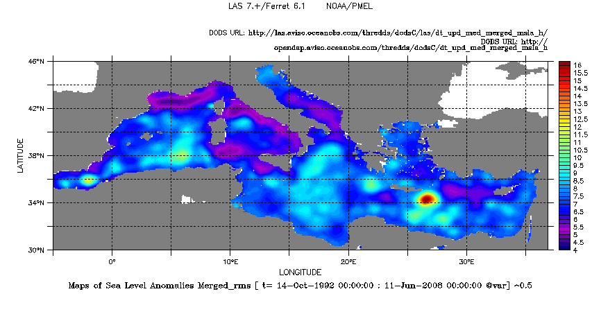
Merged Sea Level Anomaly rms in the Mediterranean Sea over all the available period October 1992- June 2008. To plot such a map, you have to select the dataset Delayed-time, the regional product, i.e. Mediterranean Sea, the variable (here Maps of Sea Level Anomalies Merged), and afterwards click on the left menu on "Define variable". You have the choose between "average", "minimum", "maximum", "sum" and "variance". So, we choose the variance and the period as defined above. Then click on "next" in order to fill in land areas and calculate the rms: in evaluate expression, we note $^0.5 to tranlate rms=√(variance). The variance map is available by clicking here.
Further information:
- Data: Delayed-time MSLA for Mediterranean Sea.
- Mediterranean Sea related-links on Aviso website.
- Pujol M.-I., 2006, "Analyse de la variabilité de surface en Méditerranée à partir des données altimétriques et comparaison aux simulations MERCATOR et MOG2D", Thesis from University Paul Sabatier, Toulouse III.
 Use the Live Access Server

