Altimetry and Doris applications in videos
Anniversaries
- Video for the 20 Years of Progress in Radar Altimetry (2012, 8'30", 82 Mo): key dates in the Earth and Ocean observations, applications, see how this continuity of 20 years of research is one of the fundamental reasons for the success of satellite altimetry.
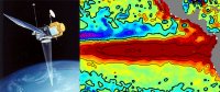
Doris, the space surveyor
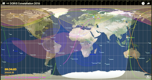
Serie of videos produced by Cnes for IDS. Videos for DORIS constellation 2016 (Cryosat-2, HY-2A, Jason-2, Jason-3, Sentinel-3A, SARAL) and videos to understand the attitude laws and solar panel orientation and rotation of the DORIS-equipped satellites. All of this material, as well as the link to the VTS website, is available on the IDS webpage. You can also watch the videos on the brand IDS video channel.
In 2010, at the the occasion of the 20th anniversary of the Doris system, videos to learn more about the technics: how does Doris measure to the closest centimetre, about the network of stations and about the applications ranging from operational oceanography modelling to climate studies.
- 2010, Doris, the space surveyor (.mpeg, 5'13'') How does Doris work : illustration of the principle of the Doppler effect. Main applications in geodesy, geophysics, or ocean levels.
- 2010, Doris, autonomous navigation (.mpeg, 1'24'') Precision of the Doris system, real-time on-board orbit determination Diode.
- 2010, Doris, network of stations (2'01'') view on the network of the 60 stations spread across the globe. Control, maintenance of this network.
DORIS constellation 2016 (Cryosat-2, HY-2A, Jason-2, Jason-3, Sentinel-3A, SARAL). Credits CNES

