Latest News
04.10.2022 October 2022: A new SWOT mission validation site in brazilian Nordeste!
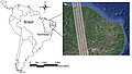
During the first six months of Swot, the satellite will be on a calibration and validation orbit. New hydrology validation sites for under this orbit are installed.
14.09.2022 2022 summer extreme events: Floods in Pakistan
One-third of Pakistan is flooded this year, much more than the usual monsoon flooding. Satellites, including altimeter ones, help in understanding and assessing the phenomena.[more]
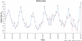
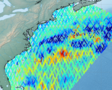
01.09.2022 September 2022: Internal tides off the Amazon shelf change with the seasons
Internal Tides have sea surface height signature of centimeters. Swot ocean data will need to be corrected from those Internal Tides to use the sea surface height information.
29.08.2022 New Atlas 3D Eddies in the Mediterranean Sea
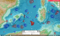
The new Mediterranean 3D Eddies Atlas product has been computed in the frame of the DYNED project. It gives contours and trackings of mesoscale eddies - derived from the Absolute Dynamic Topography (ADT) maps - and their...
23.08.2022 Altimetry-related trainings at EUMETSAT
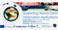
EUMETSAT is organizing trainings on ocean remote sensing, altimetry included.[more]
10.08.2022 August 2022: Thirty years of continuous altimetry

Some cornerstones and applications of altimetry these past 30 years, since the launch of Topex/Poseidon
13.07.2022 new XTRACK-L2P products available for coastal applications : Version 2022
We are pleased to announce a release of the new XTRACK-L2P Sea Level Anomalies products for coastal applications in version 2022.[more]

