Latest News
13.03.2008 North Atlantic storm generate huge waves
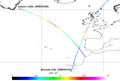
A storm hit the North-East Atlantic coast on March 10, 2008. Altimeters measured significant wave heights above 16 m.[more]
11.03.2008 Altimetry applications in videos : Aral Sea
 with altimetric satellites ground coverage.")
Satellite altimetry is an efficient tool in monitoring the level of enclosed seas, lakes and even large rivers. Since 1991, the Aral Sea is flown over - or was overflown - by a serie of altimetry satellites that measure the two...[more]
11.03.2008 3-10 March, 2008 week
Quand la mer monte...(Blog Libération, 2008/03/10) New Method To Estimate Sea Ice Thickness (Science Daily, 2008/03/07) On line availability of articles depends on the Newspaper/magazine. We can't thus certify that above...[more]
05.03.2008 March 2008: Black Sea's eddies
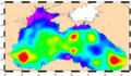
Black Sea is a singular body of water. Altimetry observes its circulations, including eddies.
04.03.2008 25 February - 01 March, 2008 week
Les déserts océaniques sont en pleine expansion (Notre planète info, 2008/02/27) Après avoir investi le ciel, les drones se jettent à l'eau (Le Monde 2008/02/27) On line availability of articles depends on the...[more]

26.02.2008 11-23 February, 2008 weeks
- Antarctic glaciers surge to ocean (BBC, 2008/02/24) - Réchauffement climatique: les glaciers des Alpes ont diminué des deux tiers (Yahoo, 2008/02/20) - Les manchots menacés par le réchauffement (le Figaro, 2008/02/14) -...[more]

