News
25.06.2008 08:14 Age: 16 yrs
Altimetry applications in videos: Mercator Océan
Category: Website updates
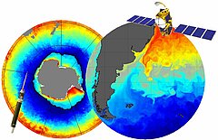
Thanks to satellite oceanography, mankind is just about beginning to understand the ocean machine, which has a decisive influence on the environment and the climate. One of the key players in this field, with its operational oceanography system, is Mercator Ocean, a French Public Interest Grouping which was established in 2002 on the initiative of its six member organisations (Cnes, CNRS, Ifremer, IRD, Météo France and Shom). Each week Mercator Ocean supplies ocean forecast bulletins (for up to 14 days) for the surface as well as the deeper layers, which describe the oceans in terms of sea surface height, currents, temperature, salinity and sea ice thickness. Its services are used for safety at sea, navigation, mitigation of pollution risks, and to generate seasonal forecasts for seafarers, oceanographers, climatologists, biologists, etc.
To achieve this result, the ocean is divided up into grids representing its four dimensions, then characterised numerically using equations and mathematical models. To ensure that this numerical portrait of the ocean is as realistic as possible, the models assimilate satellite and in situ measurements in real time, which are updated on a regular basis.
One of several satellite techniques for observing the oceans, altimetry makes a valuable contribution. Measurements of sea height provided by altimetry are a signature of what is taking place from the bottom to the surface; ocean circulation, as well as wave height and wind speed. Because they are regular, homogeneous, available in all weathers, precise and reliable, altimetry data were the first to be assimilated in the Mercator Ocean models. They have thus become the essential reference.
Because satellite observations can only determine the ocean's surface properties, in situ data profiles are also needed for ensuring consistency between satellite data and the model's simulations, for dynamically extrapolating and interpolating heterogeneous measurements over spatio-temporal scales, for better constraining ocean models at depth and for better representing water masses. Major international programmes such as Argo are being set up to ensure the widest possible coverage of the oceans with in situ floats to complement satellite programmes.
Ever since the very first forecast bulletin, which came out in January 2001, the models' resolution and precision has been constantly evolving. Today, the modelling of ice at both poles, and a global resolution of a 1/12th of a degree (available at the end of 2008) offer new potential and place Mercator Ocean among the leading world operators of operational ocean forecasting systems. The successful launch on 20th June 2008 of the Jason-2 altimetry satellite complements the constellation of satellites currently in flight, and provides Mercator Ocean with a resolution that is ideal for improving ocean forecasting in coastal areas, and for modelling smaller-scale phenomena.
The new Jason-2 altimetry satellite complements the constellation of satellites currently in flight, and provides Mercator Ocean with a resolution that is ideal for improving ocean forecasting in coastal areas, and for modelling smaller-scale phenomena.
 See the video Mercator Océan : flash (9 Mo) or mpeg (24 Mo)
Thanks to satellite oceanography, mankind is just about beginning to understand the ocean machine, which has a decisive influence on the environment and the climate. One of the key players in this field, with its operational oceanography system, is Mercator Ocean, a French Public Interest Grouping which was established in 2002 on the initiative of its six member organisations (Cnes, CNRS, Ifremer, IRD, Météo France and Shom). Each week Mercator Ocean supplies ocean forecast bulletins (for up to 14 days) for the surface as well as the deeper layers, which describe the oceans in terms of sea surface height, currents, temperature, salinity and sea ice thickness. Its services are used for safety at sea, navigation, mitigation of pollution risks, and to generate seasonal forecasts for seafarers, oceanographers, climatologists, biologists, etc.
To achieve this result, the ocean is divided up into grids representing its four dimensions, then characterised numerically using equations and mathematical models. To ensure that this numerical portrait of the ocean is as realistic as possible, the models assimilate satellite and in situ measurements in real time, which are updated on a regular basis.
One of several satellite techniques for observing the oceans, altimetry makes a valuable contribution. Measurements of sea height provided by altimetry are a signature of what is taking place from the bottom to the surface; ocean circulation, as well as wave height and wind speed. Because they are regular, homogeneous, available in all weathers, precise and reliable, altimetry data were the first to be assimilated in the Mercator Ocean models. They have thus become the essential reference.
Because satellite observations can only determine the ocean's surface properties, in situ data profiles are also needed for ensuring consistency between satellite data and the model's simulations, for dynamically extrapolating and interpolating heterogeneous measurements over spatio-temporal scales, for better constraining ocean models at depth and for better representing water masses. Major international programmes such as Argo are being set up to ensure the widest possible coverage of the oceans with in situ floats to complement satellite programmes.
Ever since the very first forecast bulletin, which came out in January 2001, the models' resolution and precision has been constantly evolving. Today, the modelling of ice at both poles, and a global resolution of a 1/12th of a degree (available at the end of 2008) offer new potential and place Mercator Ocean among the leading world operators of operational ocean forecasting systems. The successful launch on 20th June 2008 of the Jason-2 altimetry satellite complements the constellation of satellites currently in flight, and provides Mercator Ocean with a resolution that is ideal for improving ocean forecasting in coastal areas, and for modelling smaller-scale phenomena.
Further information:
- Applications: <link internal-link>Operational oceanography
- <link http: www.mercator-ocean.fr html mod_actu public welcome_en.php3 external-link-new-window>Mercator Océan


