News
12.09.2008 12:01 Age: 16 yrs
Hurricane Ike seen by Jason-2
Category: News of the Jason-2 mission
 Hurricane Ike wreaked widespread damage from Haiti to Cuba. First classified category 4 on Haiti island, it caused rains, flooding and landfall, leaving a trail of devastation. It was declassified in category 1 when it left Cuba and currently heads to Texas to become a major hurricane.
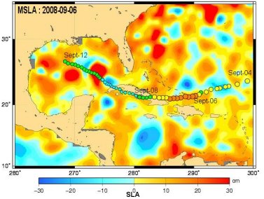
Measurements of wind speed and significant wave height (SWH), deduced from the waveform of the echo from the radar altimeter, are used to help forecasts of such phenomena. By directly measuring the sea surface heights, Jason-2 will help to detect the areas where cyclones intensify. The red warm eddy (map below) mapped with merged Sea Level Anomalies (SLA) with Ssalto/Duacs near-real time products might be an area where the cyclone gained strength when it passed.
Hurricane Ike wreaked widespread damage from Haiti to Cuba. First classified category 4 on Haiti island, it caused rains, flooding and landfall, leaving a trail of devastation. It was declassified in category 1 when it left Cuba and currently heads to Texas to become a major hurricane.
Measurements of wind speed and significant wave height (SWH), deduced from the waveform of the echo from the radar altimeter, are used to help forecasts of such phenomena. By directly measuring the sea surface heights, Jason-2 will help to detect the areas where cyclones intensify. The red warm eddy (map below) mapped with merged Sea Level Anomalies (SLA) with Ssalto/Duacs near-real time products might be an area where the cyclone gained strength when it passed.
Jason-2 made some measurements of hurricane Ike crossing the Gulf of Mexico.
<link fileadmin images news mod_actus ike_sla_21433.jpg download> |
| Huricane Ike intensity overlayed on a merged Sea Level Anomalies (SLA) map. The hurricane intensity scale is blue for cat. 1, green for cat. 2, yellow for cat. 3 and orange for cat.4. The dates near the path indicates the date when the hurrine passed, while the date in the upper left corner indicates the date of the SLA NRT map. (Credits CLS/Cnes, Ssalto/Duacs). |