News
05.02.2010 17:41 Age: 15 yrs
Hurricane Oli seen by altimetry
Category: News of the Jason-2 mission, Ocean and climate news
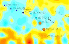 Islands of French Polynesia in Pacific Ocean have been hit by the hurricane Oli since the beginning of February. Oli is classified in Category 4 (winds > 213 km/h) on February 4 off Bora-Bora islands. Rainfall and high seas have damaged lands. During the current El Niño episode, the Eastern Pacific hurricane season may be more active.
A parameter nammed Tropical Cyclonic Heat Potential (TCHP) integrates the sea level anomalies with the in-situ sea surface temperature and the mixed layer depth. Computed around the area, the TCHP shows important values (more than 140 kJ/cm²) at the end of January.
A parameter nammed Tropical Cyclonic Heat Potential (TCHP) integrates the sea level anomalies with the in-situ sea surface temperature and the mixed layer depth. Computed around the area, the TCHP shows important values (more than 140 kJ/cm²) at the end of January.
<link fileadmin images news mod_actus hurricane_oli_rt_msla_20100205.png download> | <link fileadmin images news mod_actus hurricane_oli_tchp_20100127.png download> |
|---|---|
left: Hurricane Oli intensity overlayed on a merged (SLA) map for the 5th of February. The hurricane intensity scale is purple for a tropical depression, blue for cat. 1, green for cat. 2, yellow for cat. 3, orange for cat.4 and red for category 5. The dates near the path indicates the date when the hurricane passed (Credits CLS/Cnes Ssalto/Duacs). | |

