News
25.02.2016 11:21 Age: 8 yrs
Saral: three years in orbit!
Category: News of the Saral mission
 Three years ago, the joint CNES/ISRO mission Saral was successfully launched. It embarks the first radar altimeter in Ka-band (AltiKa) providing new path for investigation in oceanography or for ice studies. These higher frequencies in Ka-band (35.75 GHz instead of 13.6 GHz for Ku-band and 5.3 GHz for C-band) offer higher spatial resolution, with more waveforms samples, so data closer between each other along the satellite ground track (~ every 180 m) and a reduced footprint.
Its 35-day repeat orbit already followed by ERS-1 (1991-2000), ERS-2 (1995-2011) and Envisat (2002-2012) is a great opportunity to extend the repeat observations.
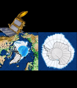
Saral, with a high inclination orbit (at 98.55°) allows an optimal coverage in high latitudes, in the Arctic and the Antarctic. Its measurements are therefore naturally used for studying the cryosphere. By observing both in high latitudes, on different orbits, the combined use of the AltiKa’s Ka-band and the Ku-band of Cryosat-2 is ideally complementary.
Three years ago, the joint CNES/ISRO mission Saral was successfully launched. It embarks the first radar altimeter in Ka-band (AltiKa) providing new path for investigation in oceanography or for ice studies. These higher frequencies in Ka-band (35.75 GHz instead of 13.6 GHz for Ku-band and 5.3 GHz for C-band) offer higher spatial resolution, with more waveforms samples, so data closer between each other along the satellite ground track (~ every 180 m) and a reduced footprint.
Its 35-day repeat orbit already followed by ERS-1 (1991-2000), ERS-2 (1995-2011) and Envisat (2002-2012) is a great opportunity to extend the repeat observations.
Saral, with a high inclination orbit (at 98.55°) allows an optimal coverage in high latitudes, in the Arctic and the Antarctic. Its measurements are therefore naturally used for studying the cryosphere. By observing both in high latitudes, on different orbits, the combined use of the AltiKa’s Ka-band and the Ku-band of Cryosat-2 is ideally complementary.
Following the successful launch of the Saral mission three years ago, the reliability and performances of its Ka-band altimeter have been demonstrated. In the frame of PEACHI project, maps of sea ice extent in Arctic and Antarctic are computed and shown here.
<link internal-link> | |||
|---|---|---|---|
Proportion of ice measurements from Saral/AltiKa waveforms classification from Oct.2014 (available by playing the animation). Waveform classification in function of the return echo shape enables to discriminate sea ice from ocean and allows to deduce sea ice extent . Credits CLS/CNES. |
Further information:
- Missions: <link internal-link>Saral
- Applications: Ice and Cryosphere: <link internal-link>Sea ice extent seen by altimeters

