News
17.01.2017 13:14 Age: 7 yrs
Jason-3's first birthday
Category: News of the Jason-3 mission
 Launched one year ago on 17 January 2016, Jason-3 is operated by the NOAA in partnership with NASA, CNES and EUMETSAT.
By succeeding TOPEX/Poseidon, Jason-1, and OSTM/Jason-2, Jason-3 extends the high precision altimetry data record to support climate monitoring, operational oceanography and seasonal forecasting. Launched in January 17th 2016, Jason-3 is operated by NOAA in partnership with NASA, CNES and EUMETSAT.
After its launch, Jason-3 successfully reached its operational orbit where all the instruments were rapidly switched on. The first real-time Jason-3 data product was generated and compared with Jason-2, less than three days after launch.
On June 2016, the Calibration/Validation results was discussed by the four partner agencies (CNES, NASA/JPL, EUMETSAT and NOAA) attended by the scientits. Consequenlty, the authorization was given to deliver the OGDR and IGDR products to all users.
Since September 2016, the new mission Jason-3 integrates the Ssalto/Duacs multimission system for Level-3 and Level-4 products (in the new 4-satellite configuration: Jason-3, Jason-2 interleaved orbit, Saral/AltiKa and Cryosat-2). Jason-3 is now the reference mission used for the altimeter inter-calibration processing.
Early November, and following recommendations made by the OSTST Science Team in La Rochelle, the Jason-3 Joint Steering Group formally endorsed the dissemination of GDR to public.
Long life to Jason-3!
Launched one year ago on 17 January 2016, Jason-3 is operated by the NOAA in partnership with NASA, CNES and EUMETSAT.
By succeeding TOPEX/Poseidon, Jason-1, and OSTM/Jason-2, Jason-3 extends the high precision altimetry data record to support climate monitoring, operational oceanography and seasonal forecasting. Launched in January 17th 2016, Jason-3 is operated by NOAA in partnership with NASA, CNES and EUMETSAT.
After its launch, Jason-3 successfully reached its operational orbit where all the instruments were rapidly switched on. The first real-time Jason-3 data product was generated and compared with Jason-2, less than three days after launch.
On June 2016, the Calibration/Validation results was discussed by the four partner agencies (CNES, NASA/JPL, EUMETSAT and NOAA) attended by the scientits. Consequenlty, the authorization was given to deliver the OGDR and IGDR products to all users.
Since September 2016, the new mission Jason-3 integrates the Ssalto/Duacs multimission system for Level-3 and Level-4 products (in the new 4-satellite configuration: Jason-3, Jason-2 interleaved orbit, Saral/AltiKa and Cryosat-2). Jason-3 is now the reference mission used for the altimeter inter-calibration processing.
Early November, and following recommendations made by the OSTST Science Team in La Rochelle, the Jason-3 Joint Steering Group formally endorsed the dissemination of GDR to public.
Long life to Jason-3!
One year ago, the Jason-3 satellite was successfully launched.
<link internal-link> |
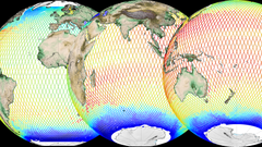
Near-Real-Time Along-track Absolute Dynamic Topography (in meters) seen by Jason-3 between 2017/01/07 and 2017/01/17, so during one cycle (10 days). This corresponds to the sea level height due to the ocean dynamics, i.e. the currents, variability, changes etc. They are the sum of the Sea level anomalies and the Mean Dynamic Topography. See the animation around the globe by clicking on the image or <link internal-link>here. Credits CNES/CLS 2017, produced by Aviso+/DUACS.
|

Further information:
- Missions: <link internal-link>Jason-3
- Data:
- Level-2: <link internal-link>GDR, IGDR
- Level-3: <link internal-link>Along-track Absolute Dynamic Topography
- Level-4: <link internal-link>Gridded Absolute Dynamic Topography

