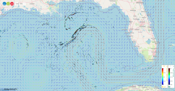
Sargassum in the Loop current
Image of the Month -

The Sargassum follow the main path of the Loop Current and also an eddy North of it. A few detections around another eddy West of those are also visible (credit CLS, contained modified Copernicus EU data).
Sargassum seaweeds were reported for the first time when European sailors crossed the North Atlantic at the end of the 15th century. Their presence there, in the middle of the North Atlantic gyre, is normal and even necessary for a number of species, as nursery habitat for small turtles, eels' spawning ground, etc. However, Sargassum have begun showing all over the Carribean and Gulf of Mexico coasts for some years now. There, they rot on the beaches, deplete the environment resources, block animals' paths or even navigation.
However, they float in mats at the ocean surface, which are visible from space. Sentinel-3 OLCI sensor (ocean-color), or the geostationnary GEOS-16 ABI sensor, make it possible to spot them floating on the ocean. Then, physical oceanography models (assimilating altimetry), or even currents derived from altimetry and winds can be used to forecast where they should probably drift and be washed ashore. Studying their seasonal patterns and interannual variations could also be helpful in order to better understand and to lessen the damages they cause.
See also:
- Image of the Month, April 2016: One thousand drifters and one (future) satellite in the Gulf of Mexico
- Image of the Month, April 2003: A looping current
- Applications: Oceanography / multi-sensors
- Applications: Biology
- Data: Sargassum detection products
Other websites on this subject:
- Operational tool (CLS)


