The Amazon under close surveillance
Image of the month - October 2001
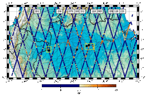
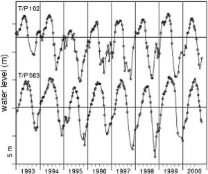
The Amazon is the world's largest river system, but it is poorly understood because few in-situ measurements from its remote regions are available. This river is in many places large enough to reflect well the radar wave from the altimeter. Thus altimetry satellites are now being used to monitor its water level variations, permanent and temporary flood zones, and various other parameters, fro a better water and natural hazard management in this region.
More and more satellite altimetry is being used over other surfaces than ocean and sea like lakes, rivers and even flat surfaces (deserts...). For this, special processing must be done, in order to take acount of the different ways the radar beam can be reflected.

