Tidal currents make a buoy's path spiral
Image of the Month - February 2017
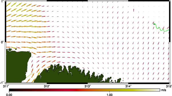
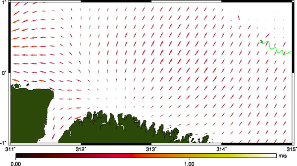
Tidal currents (from FES2014 model), a bit off Brazil at the Equator on January 6, 2017 at 11 and 19h UTC. A buoy launched in the Equatorial Atlantic for the Argonautica educational project is making spiralling moves in time with those currents -- download the whole animation (in avi, flv or mp4, 20 MB) (Credits Cnes/CLS)
When thinking about tides, people mostly imagine a beach covered and uncovered by water. However, tides translate also in terms of currents, with the same kind of periodicity than water height variations. In the open ocean, this effect is slight, but when on the continental shelf, they can be quite noticeable.
During last Vendée Globe around the world alone sail race, some skippers launched buoys (undragged ones) for the Argonautica educational project (CNES). One was launched during the trip to the South, in the Atlantic close to the Equator. The buoy, named IESO2017 by the students, began traveling due West, in a more or less straight line following the South Equatorial current. But as soon as it reached the continental shelf, the path began to make loops, with a periodicity of about 12 hours. When comparing these spirals with tidal currents, the match is perfect for at least two weeks - and even then a hint of periodicity can be seen. Now the buoy is approaching the Brazilian coasts, near the bay where the town of Belem stands.
Altimetry helped to improve the tide models by providing water height in the middle of the ocean where no tide gauge can be installed, and is still helping. In turn, tide models are used to remove tidal heights from the altimetry data - when the study is not focused on this phenomenon. The next challenge will be improving even more the tide models to be used for the SWOT mission, with new effects visible due to the 2D-mapping of this satellite, and to its precision.
See also:
- Data: FES 2014 tide model
- Image of the Month, Oct 2000: Sun and Moon shape tides on Earth
- Applications: Ocean/Tides
Other web sites on this topic:
- Argonautica educational project (in French) and data access (in English and French)

